
Official name Vanderkloof Dam Construction began 1973 Height 108 m Surface area 133.4 km² | Opening date 1977 Opened 1977 Annual generation 932 GWh (3,360 TJ) | |
 | ||
Owner Department of Water and Sanitation Similar Gariep Dam, Bloemhof Dam, Sterkfontein Dam, Palmiet Pumped Storage S, Ankerlig Power Station | ||
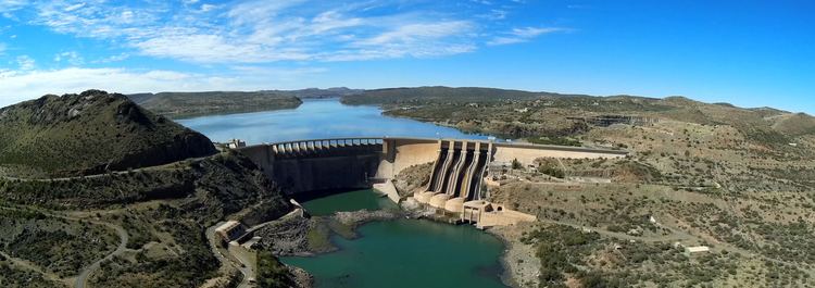
The Vanderkloof Dam (originally the P. K. Le Roux Dam) is situated approximately 130 km (81 mi) downstream from Gariep Dam and is fed by the Orange River, South Africa's largest river. Vanderkloof Dam is the second-largest dam in South Africa (in volume), having the highest dam wall in the country at 108 metres (354 ft). The dam was commissioned in 1977; it has a capacity of 3,187.557 million cubic metres (2,584,195 acre·ft) and a surface area of 133.43 square kilometres (51.52 sq mi) when full. Other rivers flowing into this dam are the Berg River, two unnamed streams coming in from the direction of Reebokrand, the Knapsak River, Paaiskloofspruit, Seekoei River, Kattegatspruit and the Hondeblaf River, in a clockwise direction.
Map of Vanderkloof Dam, South Africa
References
Vanderkloof Dam Wikipedia(Text) CC BY-SA