
Website www.cmpraia.cv | Postal code 7600 | |
 | ||
Várzea is the westernmost part of the center of the capital city of Praia in the island of Santiago, Cape Verde. It is the fourth historic area.
Contents
Its total area is about 90 to 100 hectares. Buildings and Facilities are in the eastern part while the residential area are in the western part. Its elevations varies from about 5 meters to the east to 30 meters in the west.
Bordering neighbourhoods includes Fazenda in the north, Platô in the east, Gamboa or Chā das Areias in the south, Terra Branca, Bela Vista and Tira Chapéu in the west and Craveiro Lopes to the northeast.
History
Early in the 16th century, the low-lying areas were forested with kapok trees, they were cut down to make room for farming and agriculture, the forest stretched up to Ribeira Grande. Várzea is the Portuguese word for woodland, a part dominated by a kilometer long and 300 meters wide and covered about 30 hectares. Some portions of the forest were restored mainly with palm in the 18th century and the remainder restored with kapok trees and intermingled with buildings and landmarks built in the 1950s and the mid 20th century, a dense palm grove as they were in the mid-20th century no longer exist. Kapok trees reforested the area and later intermingled the area, until 1998 a part of it remained an open space until another buildings appear, the densest part is to the north.
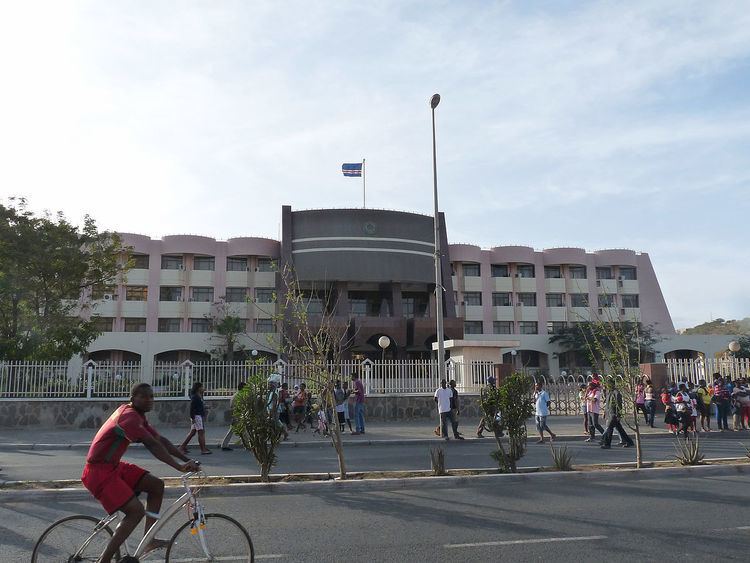
Agriculture including cattle, tropical fruits and date palm dominate the area. Urbanization started in the 1950s and Estádio da Várzea started to appear. After Cape Verde became independent, the National Assembly Building was built. The [[National Library] of Cape Verde] opened its doors in 1999 and is a street north of the stadium, also a monument commemorating Amílcar Cabral was erected north of the library. The Economic Building was added just south of the outer football (soccer) field in 2013.
Praia's football (soccer) clubs between 2001 and 2006 temporarily played at Sucupira before it was repaired and renovated. The field is now a smaller size and a building built on top of a former field.
In 2007, housing developments popped up in the west of the neighborhood all the way to the neighborhood limits and the hill of Eugénio Lima and continues in the present day, that portion was once undeveloped.
About Várzea
The most notable attraction is Estádio da Várzea, a stadium and a sports complex. It is the main home of Académica, Boavista, Desportivo, Sporting, Travadores and Vitória football (soccer) clubs.
The chief street is an avenue, the Avenida de Cidade de Lisboa (City of Lisbon), a long divided avenue containing 2 lanes and running more than a kilometer long, the main buildings of Várzea are on the avenue. The southern part of the avenue serves as a main route between Praia and Cidade Velha in Ribeira Grande and Porto Mosquito (the EN1-ST2) and the whole as a bypass connector with the route connecting Praia and the north of the island (the EN1-ST1) with a roundabout northeast of the plateau along with the Circular Road, the port and the airport. Other streets includes Avenida de China which is the second main street, a small part of Avenida de Cuba, Rua da Várzea which is the third main street, Rua de Sucupira and the old Praia-Cidade Velha Road. Inside the southernmost circle is the monument named Homem de Pedra (Man of Stone). Residential streets include one named after the sports club Associação Black Panthers which currently has a basketball club.
Capeverdean sports federations including football and volleyball are headquartered in Várzea.
Sucupira dominates the north of Várzea. It has a smaller football field which was once used by Académica Praia. Also in the northernmost portion next to Fazenda is Praia's main market known as Sucupira, its width is 100 meters and is at the northern end of Avenida Cidade de Lisboa. The origin of the name is named after the popular name of different species of plants in Brazil that are called sucupira (etymology: Tupi language: suku'pira), the plants that are similar to Cape Verdean trees, the trees remain today in that portion.
Praia's cemetery is in the western part.
One of four variants of tabanka is the Várzea variant common in the neighborhood and used in other parts of the west of the city.
The Instituto Nacional de Estatística (INE, the National Statistics Institute) is in the south of the neighborhood located at 18 Avenida Cidade de Lisboa.
Landmarks and points of interest
Panoramics
It offers the least panoramics other than the Praia area and parts of the south of the island though the island's tallest summit Pico da Antónia are seen.
Transportation
Six transit lines passes through the plateau often or sometimes, the last three do not cross by the Atlantic, they include:
Minibus (yasi) services between Praia and Cidade Velha as a secondary route together with Praia-Assomada-Tarrafal crosses the main road.