
Norse name ve-øy Area rank 205= Population 0 | OS grid reference HU313929 Highest elevation 70 m (230 ft) Area 45 ha Island groups Shetland, British Isles | |
 | ||
Meaning of name possibly Old Norse for "island of the sacred place" | ||
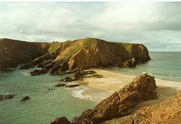
Uyea is an uninhabited tidal island located to the northwest of Mainland, Shetland. Uyea lies off the Northmavine peninsula, from where it can be reached by foot at low tide. The island's highest elevation is 70 metres (230 ft) and its area is 45 hectares (0.17 sq mi).
Map of Uyea, United Kingdom
There are several natural arches on its rocky coast, as well as challenging rock climbs. Surrounding skerries include Big Nev, Dorra Stack, Little Nev, Out Shuna Stack, Robert Irvine's Skerry, and The Burrier.
References
Uyea, Northmavine Wikipedia(Text) CC BY-SA