
Main source Lake Meirānu Source elevation 138 m Country Russia | Length 176 km Mouth Velikaya River Cities Kārsava | |
 | ||
River mouth Velikaya
138 metres (453 ft) Basin size 3,000 square kilometres (1,200 sq mi) Discharge Average rate:
0.6 cubic kilometres (0.14 cu mi) | ||
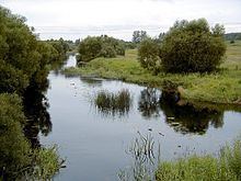
The Utroya (Russian: Утроя, in Latvian the Rītupe) is a river of Latvia and Pytalovsky and Ostrovsky Districts of Pskov Oblast of Russia, a left tributary of the Velikaya River. It is 176 kilometres (109 mi) long, and the area of its basin 3,000 square kilometres (1,200 sq mi). The principal tributary is the Lzha (the Ludza, right). The towns of Kārsava and Pytalovo are located on the banks of the Rītupe/Utroya.
Map of r. Utroya, Pskov Oblast, Russia
The source of the Rītupe is Lake Meirānu in the lake district south of the town of Kārsava. The river flows north, passes 2 kilometres (1.2 mi) from the center of Karsava, at a short stretch makes the state border between Latvia and Russia, and crosses into the Russian territory, to Pytalovsky District of Pskov Oblast. The official name of the river in Russia is the Utroya. The river further flows northwest, passes the town of Pytalovo, crosses into Ostrovsky District, accepts the Lzha from the right, and turns north. The mouth of the Utroya is in the village of Larino.
The drainage basin of the Utroya includes areas in the northeastern Latvia, as well as almost whole Pytalkovsky District, the western part of Ostrovsky District, as well as minor areas in the western part of Krasnogorodsky District of Pskov Oblast in Russia.