
Local time Monday 5:39 AM | Population 12,800 (Sep 2016) | |
 | ||
Time zone Japan Standard Time (UTC+9) Weather 1°C, Wind N at 3 km/h, 90% Humidity Points of interest Urakawa Choritsu Kyodo M, Mount Kamui, Mt Rakko | ||
Urakawa (浦河町, Urakawa-chō) is a town located in Urakawa District, Hidaka Subprefecture, Hokkaido, Japan.
Contents
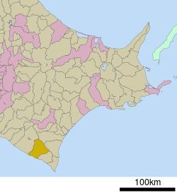
Map of Urakawa, Urakawa District, Hokkaido Prefecture, Japan
As of 2016, the town has an estimated population of 12,800 and a density of 18 persons per km². The total area is 694.24 km².
Climate
Urakawa has depending on the method used a humid continental (Köppen Dfb) or a borderline oceanic climate (Cfb) with warm summers and cold winters. Owing to its slightly more southerly latitude, easterly aspect and location on the sea, snowfall is much lighter than in the major cities of western Hokkaido like Sapporo, Hakodate, Asahikawa and Wakkanai, with the most in one month being 0.98 metres (38.6 in) in January 1969. Precipitation in heaviest in the summer months when remnant typhoons may approach; the heaviest daily rainfall being 190.0 millimetres (7.48 in) on 5 August 1981 and the wettest month August 1995 with 429.5 millimetres (16.91 in). The driest month has been February 2003 with 2.5 millimetres (0.10 in). Year-round sunshine, although less than in the Tokachi Plain, is also higher than western Hokkaido, with the dullest month being August 1941 with 48.0 hours and the sunniest April 2014 with 288.0 hours beating the previous record of 271.6 hours from May 1957.