
Country United States County Monmouth Time zone Eastern (EST) (UTC-5) Elevation 90 cm Population 5,805 (2013) Area code 732 | Incorporated April 16, 1925 Area 4.892 km² Zip code 07735 Local time Friday 12:08 PM | |
 | ||
Area rank 422nd of 566 in state33rd of 53 in county Weather 5°C, Wind E at 27 km/h, 97% Humidity | ||
3 14 17 union beach new jersey blizzard
Union Beach is a borough in Monmouth County, New Jersey, United States. As of the 2010 United States Census, the borough's population was 6,245, reflecting a decline of 404 (-6.1%) from the 6,649 counted in the 2000 Census, which had in turn increased by 493 (+8.0%) from the 6,156 counted in the 1990 Census.
Contents
- 3 14 17 union beach new jersey blizzard
- Map of Union Beach NJ 07735 USA
- Geography
- Natural disaster
- Census 2010
- Census 2000
- Local government
- Federal state and county representation
- Politics
- Education
- Roads and highways
- Public transportation
- Controversy
- Notable people
- In popular culture
- References
Map of Union Beach, NJ 07735, USA
Union Beach was formed as a borough by an act of the New Jersey Legislature on March 16, 1925, from portions of Raritan Township (now Hazlet), based on the results of a referendum held on April 16, 1925. A 100-acre (40 ha) farm in the future borough was owned by the Poole family since the days of the American Revolutionary War. Following the development of the Central Railroad of New Jersey, the Poole Farm became the site of the Union Subdivision in 1908, while an area that had been called East Point Beach Estates was renamed Union Beach by developer Charles Carr in 1920.
The borough is part of the Bayshore Regional Strategic Plan, an effort by nine municipalities in northern Monmouth County to reinvigorate the area's economy by emphasizing the traditional downtowns, dense residential neighborhoods, maritime history, and the natural beauty of the Raritan Bayshore coastline.
Geography
According to the United States Census Bureau, the borough had a total area of 1.889 square miles (4.894 km2), including 1.804 square miles (4.673 km2) of land and 0.085 square miles (0.221 km2) of water (4.52%).
Union Beach has undergone extensive restoration of its beach front, which offers a view of the New York City skyline and the Verazanno-Narrows Bridge.
A monument to the victims of the September 11, 2001 terrorist attacks, constructed of black stone and dedicated in June 2002, is positioned to allow visitors to see past the memorial towards the location where the World Trade Center towers were visible from the borough.
Unincorporated communities, localities and place names within the borough include Lorrillard Beach, Natco, Union Gardens and Van Marters Corner.
The borough borders the Monmouth County municipalities of Hazlet, Keansburg and Keyport.
Natural disaster
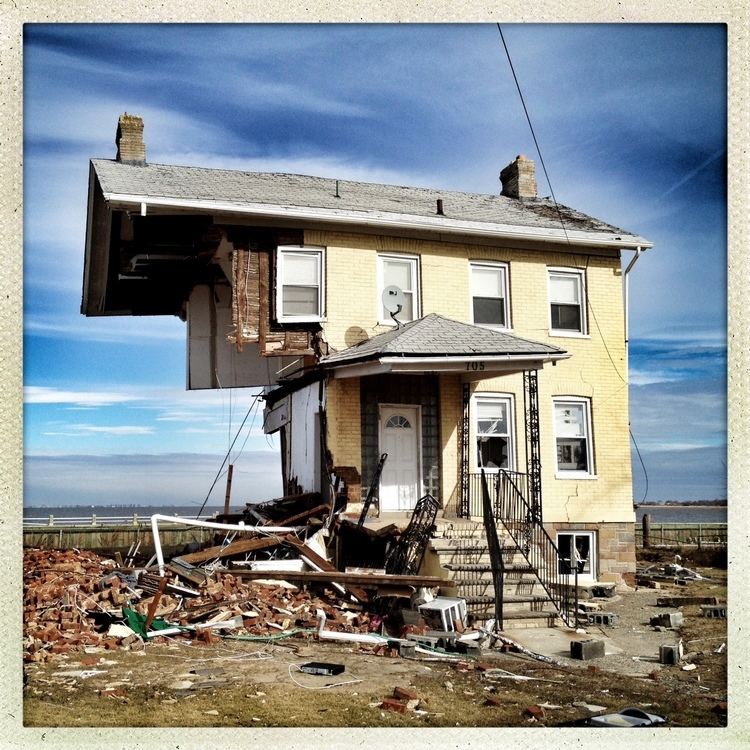
On October 28, 2012, at 4:00pm, a mandatory evacuation was ordered for the entire borough was ordered by the mayor in preparation for Hurricane Sandy, the most destructive hurricane of the 2012 Atlantic hurricane season, as well as the second-costliest hurricane in United States history. Nearly a third of the borough's more than 6,200 residents had left by the time the worst of Hurricane Sandy had arrived.
By morning, the videos and photos seen on television and social media left the state and the entire world in shock. Of the estimated 2,143 households in the borough, approximately 200 homes and businesses were damaged, 400 took on an estimated 6 or more feet of water, 62 were "completely missing" with an additional 100 that had shifted off foundations and were no longer habitable. The boroughs police department initially had to borrow several police cruisers. Municipalities from as far away as Wilmington, NC and Clay County, Florida donated police cruisers. The majority cars were destroyed when flooding reached police headquarters. Former residents from around the country mobilized and organized relief efforts, sending relief supplies, including advising and assisting overwhelmed Union Beach public servants in acquiring replacements of lost emergency vehicles. The Municipality lost 14 police cars, 3 ambulances and 4 fire trucks. Madison Township and Wanaque each gave repurposed police cruisers fully decaled with Union Beach logos, as well as other relief. Some local agencies sold old police cruisers for one dollar each or donated police cars, and donations of two cars each came from North Carolina and Florida. EMS and fire trucks were also donated from near and far.
One of the many businesses in borough to be destroyed was Jakeabob's Bay. One of the major employers in town, the restaurant was a popular summer hangout with its waterfront tiki bar deck and views of the Manhattan skyline. On the morning of October 28 the restaurant was boarded up and prayers were said in hope that the bar that survived Hurricane Irene in 2011 will survive what was to become the most destructive storm in history. By morning, the building was completely destroyed. The storm surge had completely washed through the building, pushing out tables, chairs, menus and displays. The restaurant's famous deck was found blocks inland in a resident's front yard. Its owner, Gigi Liaguno-Dorr, immediately began to organize the relief and rebuilding efforts, but not for her restaurant, but for Union Beach. The building was eventually razed when neither of the insurance companies that covered the restaurant would pay out. Five months later, in April, a new temporary restaurant was able to open in a rented space further inland but still in town called "Jakeabob's Off the Bay". The main focus of the new location was Union Beach and its destruction by Hurricane Sandy. Liaguano-Dorr used the front doors from homes destroyed in the storm as tables and partitions in the restaurant. The walls were adorned with mementos donated by Union Beach residents and photographs from years past. After barely a year, it was announced that Jakeabob's Off the Bay would not be renewing its lease with the temporary location. After months of fighting with the Federal Emergency Management Agency and its insurance company, there wouldn't be enough money to keep operating without loans or the insurance to be paid out.
Union Beach Memorial School, the borough's only school, was inundated with floodwaters and debris when the storm surge and extreme high tide swept through the borough. "It was a disaster. There was just muck and mud everywhere, mulch all over the building," principal Brian Walsh had said in an interview. Hundreds of library books and teaching materials were destroyed along with thousands of dollars worth of instruments. Music teacher Marilouise Metz said she lost decades worth of memorabilia including pictures, photos, newspaper clippings. After several months or emergency repairs by volunteers, including students and teachers, the renovations including new floors, walls, desks and murals painted by teachers, students and volunteers were finished just in time to finish out the school year. The school had been used as an evacuation center but began taking on water as the storm raged.
Census 2010
The 2010 United States Census counted 6,245 people, 2,143 households, and 1,624 families residing in the borough. The population density was 3,461.5 per square mile (1,336.5/km2). The borough contained 2,269 housing units at an average density of 1,257.7 per square mile (485.6/km2). The racial makeup of the borough was 91.05% (5,686) White, 1.54% (96) Black or African American, 0.16% (10) Native American, 1.81% (113) Asian, 0.00% (0) Pacific Islander, 3.09% (193) from other races, and 2.35% (147) from two or more races. Hispanics or Latinos of any race were 10.98% (686) of the population.
Out of a total of 2,143 households, 34.5% had children under the age of 18 living with them, 56.0% were married couples living together, 12.8% had a female householder with no husband present, and 24.2% were non-families. 18.7% of all households were made up of individuals, and 5.6% had someone living alone who was 65 years of age or older. The average household size was 2.91 and the average family size was 3.32.
In the borough, 24.0% of the population were under the age of 18, 8.9% from 18 to 24, 27.1% from 25 to 44, 30.8% from 45 to 64, and 9.3% who were 65 years of age or older. The median age was 38.6 years. For every 100 females the census counted 98.4 males, but for 100 females at least 18 years old, it was 96.3 males.
The Census Bureau's 2006-2010 American Community Survey showed that (in 2010 inflation-adjusted dollars) median household income was $61,347 (with a margin of error of +/- $10,084) and the median family income was $76,744 (+/- $15,912). Males had a median income of $55,000 (+/- $5,759) versus $36,002 (+/- $3,887) for females. The per capita income for the borough was $24,982 (+/- $1,875). About 3.1% of families and 4.9% of the population were below the poverty line, including 3.4% of those under age 18 and 4.0% of those age 65 or over.
Census 2000
As of the 2000 United States Census there were 6,649 people, 2,143 households, and 1,722 families residing in the borough. The population density was 3,545.1 people per square mile (1,365.5/km2). There were 2,229 housing units at an average density of 1,188.5 per square mile (457.8/km2). The racial makeup of the borough was 94.45% White, 0.87% African American (U.S. Census), 0.20% Native American, 1.23% Asian, 1.35% from other races, and 1.90% from two or more races. Hispanic or Latino of any race were 8.09% of the population.
There were 2,143 households out of which 43.3% had children under the age of 18 living with them, 62.7% were married couples living together, 12.2% had a female householder with no husband present, and 19.6% were non-families. 15.5% of all households were made up of individuals and 5.5% had someone living alone who was 65 years of age or older. The average household size was 3.09 and the average family size was 3.44.
In the borough the population was spread out with 29.1% under the age of 18, 8.3% from 18 to 24, 33.0% from 25 to 44, 22.1% from 45 to 64, and 7.5% who were 65 years of age or older. The median age was 34 years. For every 100 females there were 102.0 males. For every 100 females age 18 and over, there were 97.9 males.
The median income for a household in the borough was $59,946, and the median income for a family was $65,179. Males had a median income of $45,688 versus $29,918 for females. The per capita income for the borough was $20,973. 4.8% of the population and 4.2% of families are below the poverty line. Out of the total people living in poverty, 5.6% are under the age of 18 and 5.9% are 65 or older.
Local government
Union Beach is governed under the Borough form of New Jersey municipal government. The governing body consists of a Mayor and a Borough Council comprising six council members, with all positions elected at-large on a partisan basis as part of the November general election. A Mayor is elected directly by the voters to a four-year term of office. The Borough Council consists of six members elected to serve three-year terms on a staggered basis, with two seats coming up for election each year in a three-year cycle. The Borough form of government used by Union Beach, the most common system used in the state, is a "weak mayor / strong council" government in which council members act as the legislative body with the mayor presiding at meetings and voting only in the event of a tie. The mayor can veto ordinances subject to an override by a two-thirds majority vote of the council. The mayor makes committee and liaison assignments for council members, and most appointments are made by the mayor with the advice and consent of the council.
As of 2016, the Mayor of Union Beach is Republican Paul J. Smith Jr., whose term of office ends December 31, 2019. Members of the Borough Council are Council President Albin J. Wicki (R, 2018), Louis S. Andreuzzi (R, 2017), Charles W. Cocuzza (R, 2018), Timothy Perrella (D, 2016), Cherlanne Roche (R, 2017) and Jeffrey D. Williams (D, 2016).
In December 2015, the Borough Council appointed Timothy Perrella to fill the vacant seat expiring in December 2016 that had been held by Lawrence T. Mascilak until his resignation in October.
Federal, state and county representation
Union Beach is located in the 6th Congressional District and is part of New Jersey's 13th state legislative district.
New Jersey's Sixth Congressional District is represented by Frank Pallone (D, Long Branch). New Jersey is represented in the United States Senate by Cory Booker (D, Newark, term ends 2021) and Bob Menendez (D, Paramus, 2019).
For the 2016–2017 session (Senate, General Assembly), the 13th Legislative District of the New Jersey Legislature is represented in the State Senate by Joseph M. Kyrillos (R, Middletown Township) and in the General Assembly by Amy Handlin (R, Middletown Township) and Declan O'Scanlon (R, Little Silver). The Governor of New Jersey is Chris Christie (R, Mendham Township). The Lieutenant Governor of New Jersey is Kim Guadagno (R, Monmouth Beach).
Monmouth County is governed by a Board of Chosen Freeholders consisting of five members who are elected at-large to serve three year terms of office on a staggered basis, with either one or two seats up for election each year as part of the November general election. At an annual reorganization meeting held in the beginning of January, the board selects one of its members to serve as Director and another as Deputy Director. As of 2014, Monmouth County's Freeholders are Freeholder Director Lillian G. Burry (R, Colts Neck Township; term ends December 31, 2014), Freeholder Deputy Director Gary J. Rich, Sr. (R, Spring Lake; 2014), Thomas A. Arnone (R, Neptune City; 2016), John P. Curley (R, Middletown Township; 2015) and Serena DiMaso (R, Holmdel Township; 2016). Constitutional officers elected on a countywide basis are County Clerk M. Claire French (Wall Township), Sheriff Shaun Golden (Farmingdale) and Surrogate Rosemarie D. Peters (Middletown Township).
Politics
As of March 23, 2011, there were a total of 3,782 registered voters in Union Beach, of which 887 (23.5%) were registered as Democrats, 667 (17.6%) were registered as Republicans and 2,228 (58.9%) were registered as Unaffiliated. There were no voters registered to other parties.
In the 2012 presidential election, Democrat Barack Obama received 52.6% of the vote (1,109 cast), ahead of Republican Mitt Romney with 46.3% (976 votes), and other candidates with 1.0% (22 votes), among the 2,119 ballots cast by the borough's 3,857 registered voters (12 ballots were spoiled), for a turnout of 54.9%. In the 2008 presidential election, Republican John McCain received 53.2% of the vote (1,490 cast), ahead of Democrat Barack Obama with 43.9% (1,229 votes) and other candidates with 1.5% (41 votes), among the 2,802 ballots cast by the borough's 4,103 registered voters, for a turnout of 68.3%. In the 2004 presidential election, Republican George W. Bush received 56.2% of the vote (1,569 ballots cast), outpolling Democrat John Kerry with 42.0% (1,172 votes) and other candidates with 0.9% (37 votes), among the 2,793 ballots cast by the borough's 4,114 registered voters, for a turnout percentage of 67.9.
In the 2013 gubernatorial election, Republican Chris Christie received 73.6% of the vote (1,099 cast), ahead of Democrat Barbara Buono with 24.2% (362 votes), and other candidates with 2.1% (32 votes), among the 1,520 ballots cast by the borough's 3,642 registered voters (27 ballots were spoiled), for a turnout of 41.7%. In the 2009 gubernatorial election, Republican Chris Christie received 65.5% of the vote (1,152 ballots cast), ahead of Democrat Jon Corzine with 24.6% (432 votes), Independent Chris Daggett with 7.7% (136 votes) and other candidates with 1.7% (30 votes), among the 1,759 ballots cast by the borough's 3,917 registered voters, yielding a 44.9% turnout.
Education
The Union Beach School System serves public school students in pre-kindergarten through eighth grade at Union Beach Memorial School. As of the 2012-13 school year, the district's one school had an enrollment of 730 students and 57.5 classroom teachers (on a full-time equivalent basis), for a student–teacher ratio of 12.70:1.
Public school students in ninth through twelfth grades attend Keyport High School in Keyport, as part of a sending/receiving relationship with the Keyport Public Schools. Students have the choice, as well, to apply for Red Bank Regional High School for admission into its specialized programs. High school students also have the option to apply to one of the career academies in the Monmouth County Vocational School District.
Roads and highways
As of May 2010, the borough had a total of 25.60 miles (41.20 km) of roadways, of which 22.06 miles (35.50 km) were maintained by the municipality, 2.93 miles (4.72 km) by Monmouth County and 0.61 miles (0.98 km) by the New Jersey Department of Transportation.
Route 36 runs along the borough's southern border with Hazlet Township.
Public transportation
NJ Transit local bus service is available on the 817 route.
Controversy
Union Beach made national news for fighting a wind turbine proposed by the Bayshore Regional Sewerage Authority that would be constructed within close proximity to residential houses, sensitive bird habitats, and protected wetlands. The agency received approval in October 2009 from the New Jersey Department of Environmental Protection for the turbine, which would stand 380 feet (120 m) high. The case was brought to the Supreme Court of New Jersey, which in September 2014 upheld a state law disallowing local ordinances from preventing the development of certain wind power projects in New Jersey.
Notable people
People who were born in, residents of, or otherwise closely associated with Union Beach include:
In popular culture
Union Beach was used as the eighth checkpoint of the titular race in the seventh part of the popular manga series, Jojo's Bizarre Adventure.