
Country United States FIPS code 05-70700 Area 4.1 km² Zip code 72386 Local time Monday 1:37 PM | Time zone Central (CST) (UTC-6) GNIS feature ID 0055773 Elevation 69 m Population 755 (2013) Area code 870 | |
 | ||
Weather 22°C, Wind SW at 14 km/h, 71% Humidity | ||
How to say or pronounce usa cities tyronza arkansas
Tyronza is a city in Poinsett County, Arkansas, United States. The population was 762 at the 2010 census. It is included in the Jonesboro, Arkansas Metropolitan Statistical Area.
Contents
- How to say or pronounce usa cities tyronza arkansas
- Map of Tyronza AR 72386 USA
- Geography
- History
- Demographics
- References
Map of Tyronza, AR 72386, USA
Geography
Tyronza is located at 35°29′N 90°21′W (35.487, -90.357).
According to the United States Census Bureau, the town has a total area of 4.1 km² (1.6 mi²), all land.
History
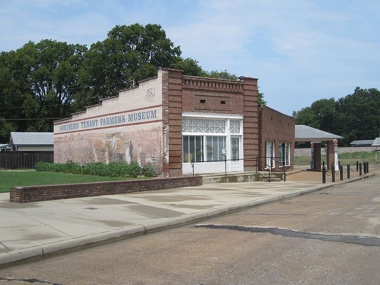
Tyronza is one of the oldest cities within Poinsett County with its origins dating back to the late 19th Century. In the 1930s it was the site where the Southern Tenant Farmers movement started that became a national outcry against the abusive discrimination of wealthy land owners against sharecroppers who were mostly African-American farmers. There is now a museum in the city run by Arkansas State University highlighting the history of the movement and the history of the region. Tyronza was also the home of Dr. L. H. McDaniel, a local physician who became friends with President Lyndon Baines Johnson through his political involvement in the Democratic Party. McDaniel was a close advisor to Johnson and U.S. House Ways and Means Chairman Wilbur D. Mills (D-Arkansas) in the creation of the Medicare and Medicaid programs which began in 1965, the year McDaniel died. He treated patients all over eastern Arkansas regardless of their ability to pay and often accepted live chickens, baked goods and garden vegetables as payment for his in-home visits. McDaniel was a national delegate to Democratic Conventions in the 1950s and brought national political and medical leaders to Tyronza with conferences he set up in huge 1,000-seat tents on the outskirts of the city. Although the community started as a farming and retail center it has become a bedroom community for many of its residents that work in Jonesboro or Memphis but who prefer the small town lifestyle.
Demographics
As of the census of 2000, there were 918 people, 363 households, and 257 families residing in the town. The population density was 225.8/km² (586.5/mi²). There were 388 housing units at an average density of 95.4/km² (247.9/mi²). The racial makeup of the town was 94.12% White, 3.70% Black or African American, 0.54% from other races, and 1.63% from two or more races. 0.65% of the population were Hispanic or Latino of any race.
There were 363 households out of which 34.7% had children under the age of 18 living with them, 54.5% were married couples living together, 12.1% had a female householder with no husband present, and 29.2% were non-families. 26.7% of all households were made up of individuals and 12.7% had someone living alone who was 65 years of age or older. The average household size was 2.53 and the average family size was 3.09.
In the town the population was spread out with 26.1% under the age of 18, 12.1% from 18 to 24, 25.6% from 25 to 44, 24.7% from 45 to 64, and 11.4% who were 65 years of age or older. The median age was 35 years. For every 100 females there were 100.0 males. For every 100 females age 18 and over, there were 96.0 males.
The median income for a household in the town was $30,188, and the median income for a family was $34,333. Males had a median income of $30,820 versus $20,625 for females. The per capita income for the town was $12,984. About 17.2% of families and 21.6% of the population were below the poverty line, including 29.3% of those under age 18 and 24.0% of those age 65 or over.