
Primary outflows Robinson Creek Outflow location Hot Creek | Surface elevation 2,610 m Cities Mammoth Lakes | |
 | ||
Settlements Mammoth Lakes, California Similar Sierra Nevada, Mammoth Mountain, Convict Lake, Rainbow Falls, Devils Postpile National | ||
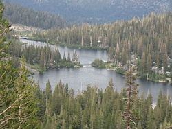
Twin Lakes is a set of connected lakes at the base of the southeastern slope of Mammoth Mountain, in Mono County of eastern California. They are in the eastern Sierra Nevada, and within the Inyo National Forest.
Map of Twin Lakes, Mammoth Lakes, CA 93546, USA
Twin Lakes are the lowest lakes in the Mammoth Lakes Basin. On one side of the lake are lava cliffs that were formed by eruptions of Mammoth Mountain. The other side of the lake has the Inyo National Forest's Twin Lakes Campground, and Tamarack Lodge of the Mammoth Mountain Ski Area.
References
Twin Lakes (Mono County, California) Wikipedia(Text) CC BY-SA