
Listing County top OS grid SO969887 Elevation 271 m | Topo map OS Explorer 219 | |
 | ||
Similar Walton Hill, Wychbury Hill, Bilberry Hill, Brown Clee Hill, Worcestershire Beacon | ||
Turners Hill or Turner's Hill is the highest hill in the West Midlands, England, at 271m above sea level. The hill is situated on the border of Dudley and Rowley Regis, in the Metropolitan Borough of Sandwell (originally Rowley Regis and from 1966 to 1974 part of Warley), in a rural part of the predominantly industrial Black Country.
Contents
Map of Turners Hill, Rowley Regis, UK
The hill can be seen from many miles away, and offers good views to Clent Hills, Kinver Edge, Shatterford Hill, Barr Beacon and on a clear day to the Shropshire and Malvern Hills. There are good views of the hill from the M5 Motorway between Junctions 1 and 2.
FeaturesEdit
There are working quarries on the southern end of the hill that are used to obtain diabase.
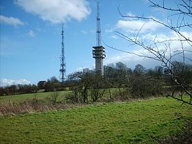
On top of the hill are two large radio transmission towers which can be seen for many miles.
Dudley Golf Course (now actually just over the border of Dudley in Sandwell) is also situated on the hill.