
Country Philippines Barangays Elevation 40 m Province Cotabato | Incorporated August 6, 1961 Time zone PST (UTC+8) Area 343.1 km² Local time Sunday 6:25 PM | |
 | ||
Region SOCCSKSARGEN (Region XII) District 3rd District of Cotabato Weather 27°C, Wind E at 8 km/h, 82% Humidity Neighborhoods Barangay Magbok, Brgy.Maybula, Brgy.Tambak | ||
Trumpet christmas carol from tulunan cotabato philippines
Tulunan is a second class municipality in the province of Cotabato, Philippines. According to the 2015 census, it has a population of 56,513 people.
Contents
- Trumpet christmas carol from tulunan cotabato philippines
- Map of Tulunan Cotabato Philippines
- Geography
- Barangays
- Climate
- History
- Demographics
- Economy
- Tourist attractions
- Notable people from Tulunan
- References
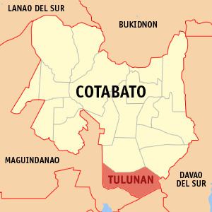
Map of Tulunan, Cotabato, Philippines
Geography
Tulunan, North Cotabato is geographically located at the southernmost part of Cotabato Province. On the north, it is bounded by M'lang; Datu Paglas, Maguindanao on the south; by Liguasan Marsh on the west; by Makilala on the north-eastern portion; and Magsaysay, Davao del Sur in the eastern part.
Barangays
Tulunan is politically subdivided into 29 barangays.
Climate
Tulunan has the climate, which is more or less evenly distributed throughout the year and a rainfall ranging from 60 mm. to 215mm. having an average annual rainfall of 115.04 mm. The months of January, February, March and December are marked dry season. All other months have occasional rains. Generally, January and December are the coldest month of the year. The average amount of temperature is 28.25 degree Celsius. The prevailing wind directions comes during wet / rainy season. Typhoon is seldom felt in the area as Tulunan is located outside of the typhoon belt and is protected by small mountains. However, during heavy rains, which cause the overflowing of river like Malasila, Tulunan and Bual Rivers, many crops and structures are destroyed.
These heavy downpours occur usually in the month of August and September. Identified places with severe flooding hazards are Barangays of: Damawato, Bual, Popoyon, Tambac, Bagumbayan, Minapan and Dungos giving a total of 1,200 hectares more or less with an equivalent of 3.43% of the total area. This climatic condition negatively affect the productivity of the farmers in the said barangays as floods could not be detected when to occur thus, destroying the crops varying from 50% to 100% of it.
History
The Tulunan is derived from a Maguindanaon word “tulun” which means “a place of abundance” or “where grace fall”. The early settlers of the place were mostly Muslim tribes who settled in the lowlands. The nomadic tribes like the B'laans, Bagobos and Tirurays occupied the hills and mountains. The first system of government was datuism and the first ruling datu of the place was believed to be Datu Enok. With the coming in of the Christian settlers from Luzon and Visayas and the inter- marriages between the new settlers with the inhabitants of the place, a marked increase in the population was noted.
Demographics
In the 2015 census, the population of Tulunan, Cotabato, was 56,513 people, with a density of 160 inhabitants per square kilometre or 410 inhabitants per square mile.
Economy
Agricultural products like rice and corn, upland rice, legumes, green onions, root crops, tobacco, rubber, vegetables, sorghum and coconuts.
Tourist attractions
Tulio Favali Shrine in Km. 125, La Esperanza, Tulunan, Divine Mercy Shrine in Lampagang, Tulunan. Spring and swimming resorts are also available like Kylex Swimming Pool and Migz Swimming Pool..