
Population 16,194 (2011) Country Wales Postcode district CF3 | OS grid reference ST230800 Sovereign state United Kingdom Dialling code +44-29 | |
 | ||
Bike ramps in trowbridge cardiff
Trowbridge is a district, electoral ward and community in the east of the city of Cardiff, capital of Wales.
Contents
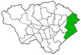
Map of Trowbridge, UK
The electoral ward includes some or all of the areas of Cefn Mably, St Mellons estate and Trowbridge in the parliamentary constituency of Cardiff South & Penarth.
It is bounded by Pontprennau & Old St. Mellons to the north west; Marshfield (in Newport principal area) to the east; and Splott and Rumney to the west.
Until 1938, the area was part of the civil parish of Rumney, in the historic county of Monmouthshire.
Schools
Trowbridge Primary School.
References
Trowbridge, Cardiff Wikipedia(Text) CC BY-SA