
Native name Rivière Trout Basin area 427.4 km² Province Québec River system Saint Lawrence River | Main source Little Trout River Source Little Trout River Country Canada | |
 | ||
Region Le Haut-Saint-Laurent Regional County Municipality Basin size 427.35 square kilometres (165.00 sq mi) | ||
Trout River (French: Rivière Trout) is a river in southwestern Quebec, Canada, which originates in various rivers including the Little Trout River in the Adirondack Mountains located in upstate New York, United States.
Map of Trout River, Qu%C3%A9bec, Canada
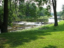
Trout River, also called Rivière à la Truite in French, is a non-navigable and non-buoyant river: it has only 427.35 square kilometres (165.00 sq mi) of drainage basin that flows between the townships of Elgin and Godmanchester in front of lots granted by the Crown prior to June 1, 1884.
Trout River has two dams: the St-Onge Dam located in the hamlet of Trout River in Elgin near the Canada–US border. The other dam is the Hooker Dam, which is located between the hamlet of Kensington in Godmanchester and the path of the second concession to Elgin. The Trout River flows into the Chateauguay River just south of the town of Huntingdon. The municipality of Huntingdon set up a Route 138 rest stop at the confluence of the two rivers.
The Commission de toponymie du Québec formalized the name on September 22, 1976.