
Formed September 2, 2008 Fatalities None reported Areas affected Socorro Island Affected area Socorro Island | Dissipated September 3, 2008 Damage None Highest winds 64 km/h | |
 | ||
Lowest pressure 1000 mbar (hPa); 29.53 inHg Date 2 September 2008 – 3 September 2008 Similar Tropical Storm Lowell, Hurricane Elida, Hurricane Hernan, Hurricane Fausto, Tropical Storm Julio | ||
Tropical Storm Karina was a weak, short-lived tropical cyclone that developed during the 2008 Pacific hurricane season. The 12th tropical cyclone and 11th named storm of the season, it originated out of a tropical wave in the North Atlantic hurricane basin. The wave entered the Pacific Ocean on August 30 and spawned an area of low pressure off the western coast of Mexico on the morning of September 1. The low had become sufficiently organized to be declared a tropical depression the next morning. The depression quickly developed into a tropical storm later in the morning, at which time it was named Karina and reached its peak intensity of 40 miles per hour (65 km/h) with a minimum pressure of 1000 mbar (hPa; 29.54 inHg). Later that day, after being classified a tropical storm for 12 hours, wind shear weakened the storm to a depression on September 3 and it dissipated shortly thereafter.
Contents
Meteorological history
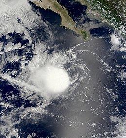
Tropical Storm Karina originated from the southern portion of the tropical wave—a tropical wave is an elongated low pressure area embedded within the easterly trade winds—that also spawned Hurricane Gustav in the Caribbean Sea. The wave crossed Central America and entered the eastern Pacific basin on August 28. After two days, the wave spawned an area of low pressure south of Manzanillo, Mexico. The low was located beneath an area of moderate convection, but was nearing cooler waters and a moist, yet stable, air mass. By later that night, a low-level circulation developed partially underneath deep thunderstorm activity. In an area favorable for development, a tropical cyclone formation alert was issued on September 2. However, strong easterly shear separated the showers and thunderstorms from the center of circulation. Despite the shear, sufficient convection developed around the center; the National Hurricane Center (NHC) classified it a tropical depression at 0600 UTC, while centered about 390 miles (630 km) south of the southern tip of Baja California. The NHC initially did not recognize the system as a tropical depression and did not initiate advisories on it until several hours later. The depression quickly intensified into a tropical storm due to a brief relaxation of the wind shear and was given the name Karina while located about 25 mi (40 km) north of Socorro Island.
Karina was located to the south of a weakening mid-level ridge, leading to a relatively slow west-northwest movement at 9 mph (15 km/h). Upon becoming a tropical storm, Karina reached its peak with winds of 40 mph (65 km/h). There was uncertainty as to the intensity of the storm, as the Dvorak technique—a system used to estimate the intensity of a tropical cyclone—rendered an intensity of 50 mph (80 km/h); but because the center of the storm had just moved under the deep convection, the winds were held at minimal tropical storm intensity. That night, 12 hours after being declared a tropical storm, Karina was downgraded to a tropical depression. Strong easterly wind shear of at least 25 mph (40 km/h) tore away the deep convection that previously surrounded Karina. Karina was moving into a stable environment over cooling waters which would prevent convection from redeveloping, despite a forecast of lessening wind shear. The forward motion gradually decreased. By the morning of September 3, convection had been sheared 125 mi (200 km) from the center of circulation, leaving only a swirl of clouds. Karina degenerated into a remnant low-pressure area later that morning and the NHC issued their final advisory. The remnant low quickly dissipated that afternoon.
Preparations and impact
When the National Hurricane Center issued its first advisory on Karina, the storm was near the island of Socorro. There were no known preparations taken before the storm, as the island is mainly a natural reserve and the only inhabitants reside in a military base. On Clarion Island, residents took minor actions to prepare for possible impact from the storm. Officials advised residents to cancel all coastal activities and comply with advice from the National Civil Protection. Small crafts were advised to exercise extreme caution. In Cabo San Lucas, officials closed the port due to high waves produced by Karina; small crafts such as water taxis and jet skis were to remain at the port. Port officials in Oaxaca and Chiapas advised boaters of strong winds, rain, and low visibility that they may encounter when nearing the seas around Karina. Despite the proximity to Socorro, no damage was reported and Karina remained far enough away from Clarion that there was no impact on the island. There were no ship reports of tropical storm-force winds.