
Formed September 25, 2002 Fatalities 3 indirect Affected areas Guerrero, Michoacán | Dissipated September 26, 2002 Damage Minimal | |
 | ||
Highest winds 1-minute sustained: 45 mph (75 km/h) Lowest pressure 1000 mbar (hPa); 29.53 inHg Date 25 September 2002 – 26 September 2002 Similar Hurricane Kenna, Hurricane Fausto, Hurricane Elida, Hurricane Hernan, Hurricane Iselle | ||
Tropical Storm Julio in 2002 was a weak and short-lived tropical storm that made landfall along the southern Mexican coast. An area of convection organized into a tropical depression on September 25. Initially forecast to stay offshore, the depression headed northward and strengthened into a tropical storm that same day. Julio turned to the northwest and peaked as a minimal tropical storm just before landfall near Lázaro Cárdenas, on September 26. The storm soon weakened into a tropical depression and later on September 26, it rapidly dissipated over Mexico.
Contents
Prior to making landfall, tropical cyclone warnings and watches were issued for a portion of the Pacific coast of Mexico. After making landfall, three fatalities and 18 injuries were reported from Julio when a bus flipped over. Around 100 houses in Acapulco and Zihuatanejo were damaged or washed away by flash flooding. In the latter city, many trees were brought down and numerous streets were flooded. The highest rainfall reported was 16.10 in (409 mm) at Zihuatanejo and La Unión, resulting in devastation. In all, about 2,000 homes were flooded while 100 families were evacuated. About a month after Julio, Hurricane Kenna affected some of the same locations as Julio.
Meteorological history
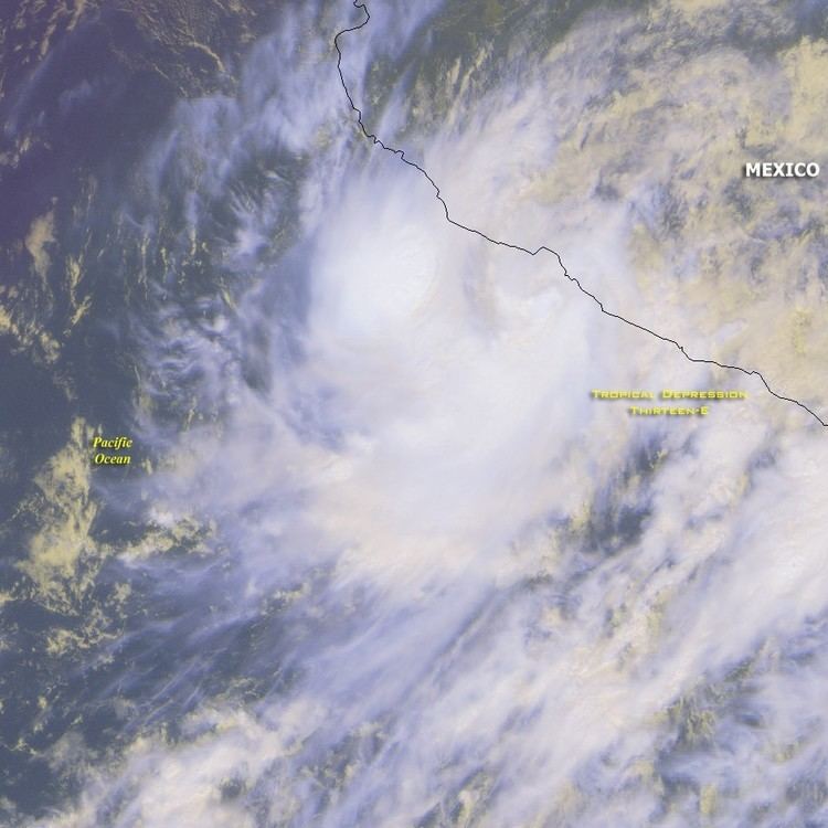
The origins of Tropical Storm Julio were from a persistent monsoon-like area of convection (possibly related to Hurricane Isidore) that was situated off the west coast of Central America on September 21. Convective activity generally increased over the next two days, and it is estimated that a poorly defined surface circulation developed late on September 23. The low gradually became better organized and at 0000 UTC on September 25, the National Hurricane Center (NHC) reported that the disturbance had developed into Tropical Depression Thirteen-E about 100 mi (160 km) southwest of Acapulco.
Initially, the storm was expected to pass very close to the Mexican coast and attain a peak intensity of 60 mph (95 km/h). Shortly thereafter, the NHC upgraded the depression into Tropical Storm Julio based on intensity estimates from the Dvorak technique. By this time, Julio was now expected to move onshore the Mexican coast and meander. At 0000 UTC on September 26, Tropical Storm Julio attained its peak intensity of 45 mph (70 km/h) while also reaching its minimum barometric pressure of 1,000 mb (30 inHg). At peak, the storm was centered just west-northwest of Lázaro Cárdenas. After turning northwest, Julio made landfall along the coast of Southwestern Mexico. After landfall, Julio rapidly deteriorated over the mountainous terrain. At 1200 UTC September 26, the storm was downgraded into a tropical depression. Even though the storm was initially expected to enter the extreme southern Gulf of California and regain tropical storm strength, Julio dissipated near Manzanillo later that day instead.
Preparations, impact, and aftermath
Upon becoming a tropical cyclone, tropical cyclone warnings and watches were issued for portions of the Pacific coast of Mexico; a tropical storm warning was issued from Zihuatanejo to Punta San Telma while a tropical storm watch was in effect from Punta San Telma to Manzanillo. On September 26, once the storm had weakened into a depression over land, all the watches and warnings were dropped. While making landfall, Zihuatanejo reported 40 mph (65 km/h) winds, with gusts up to 50 mph (80 km/h) at 2042 UTC September 25. In addition, a peak pressure of 1,002.3 mb (29.60 inHg) was reported. The highest rainfall reported was 16.10 inches (409 mm) at Zihuatanejo and La Unión, Guerrero. Record rainfall was reported in Guerrero.
Tropical Storm Julio was responsible for heavy rains to Zihuatanejo, where 100 homes were damaged or destroyed. Across the city, numerous roofs were damaged and many trees fell. Many houses and streets were flooded as well. Meanwhile, in Acapulco, heavy rains triggered flash flooding that damaged another 100 houses. Throughout Colima, many rivers overflowed its banks. Furthermore, 2,000 homes were flooded. Roughly 100 families were evacuated to shelters in Michoacán.
In addition, many small shacks lost their roof due to the storm's high winds. On the outskirts of the Taxco, situated 95 mi (155 km) inland, a school bus carrying 40 kids flipped over, killing three and injuring 18 others. An estimated 2700 acres (700 ha) of crops were lost because of the storm. Parts of Guerrero were later declared a disaster area. However, the city of Zihuaranejo was quickly cleaned up proceeding the storm. About a month after Julio, Hurricane Kenna affected some of the same locations that Julio impacted.