
Formed September 1, 2014 Fatalities 1 indirect | Dissipated September 4, 2014 Highest winds 80 km/h | |
 | ||
Lowest pressure 1000 mbar (hPa); 29.53 inHg Damage $6.5 million (2014 USD) Date 1 September 2014 – 4 September 2014 Similar Hurricane Bertha, Hurricane Cristobal, Hurricane Fay, Hurricane Edouard, Hurricane Dolly | ||
Tropical Storm Dolly was a short-lived and disorganized tropical cyclone that caused moderate damage across Tamaulipas, Mexico, in early September 2014. Originating from a tropical wave, the system first became a tropical depression late on September 1 while situated over the Bay of Campeche. Dolly struggled against strong wind shear for the duration of its existence. The large system featured multiple circulations, sometimes becoming a new dominant center and other times simply rotating around a mean vortex. As a result, multiple center relocations occurred along its general west-northwest track. Dolly eventually made landfall in Tamaulipas on September 3 before degenerating into a remnant low. The system subsequently dissipated the following day.
Contents
Prior to Dolly's landfall, schools suspended classes and officials opened shelters across Tamaulipas and Veracruz. The storm produced widespread moderate to heavy rain in Mexico, with accumulations peaking at 15.23 in (387 mm) in La Encantada, Tamaulipas. Subsequent flooding caused damage amounting to at least 87 million pesos (US$6.5 million). One fatality was indirectly attributed to the storm. Moisture from Dolly also brought scattered storms to southern Texas.
Meteorological history
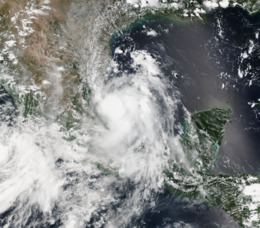
On August 19, 2014, a tropical wave emerged off the west coast of Africa. The system traversed the Atlantic over the next week with no signs of development. Convection finally increased once the wave entered the Caribbean Sea on August 27; however, it was not until August 30 when interaction with a Kelvin wave spurred organization. An area of low pressure consolidated within the system as it crossed the Yucatán Peninsula on August 31. Formation of a banding feature along the southeastern portion of the circulation on September 1 marked the system's transition into a tropical depression by 18:00 UTC while over the Bay of Campeche. Although situated over warm waters of 30 °C (86 °F), strong wind shear created an unfavorable environment and hindered intensification. During this formative stage, the depression tracked northward as its center relocated before turning to the northwest and later west. It was uncertain if a closed circulation truly existed due to conflicting data and the depression could have remained a trough until the afternoon of September 2.
Early on September 2, the depression acquired gale-force winds and became the fourth tropical storm of the 2014 season; accordingly, it was assigned the name Dolly at this time. A tight pressure gradient between Dolly and a ridge over the Gulf of Mexico created a large area of tropical storm winds along the east side of the cyclone. Data Hurricane Hunters investigating the system indicate that Dolly achieved its peak winds of 50 mph (85 km/h) around 12:00 UTC. Winds up to 70 mph (110 km/h) were found within the deep convection to the storm's east but considered to be inflated by heavy rains and thus not representative of its actual strength. Slight weakening took place shortly thereafter as the center relocated to the south. During this relocation, multiple circulations were observed rotating around a mean position with yet another vortex located well to the southeast. Around 01:00 UTC on September 3, Dolly's pressure fell to 1000 mbar (hPa; 29.53 inHg) marking the storm's peak intensity. Maintaining a due west course, Dolly made landfall just south of Tampico at 04:00 UTC with winds of 45 mph (75 km/h). Radar observations depicted a secondary center to the north that moved ashore near Altamira an hour later. Once onshore, Dolly's circulation separated from all remaining convection and the storm degenerated into a remnant low later that day. The system subsequently dissipated early on September 4.
Preparations and impact
The remnants of Dolly brought widespread moisture to southern Texas by September 5. Scattered thunderstorms developed across the region, with some producing damaging winds. More than 2 in (51 mm) of rain fell in Brownsville, causing street flooding. Dozens of Mexican fishing vessels sought refuge in the Port of Brownsville; however, two ran aground in the shipping channel and a third on South Padre Island. The United States Coast Guard attributed the mishaps to the sudden influx of numerous ships.
Southerly flow from Hurricane Norbert over the Pacific brought moisture from Dolly over the Southwestern United States, resulting in possible life-threatening flash flooding.
Mexico
Coinciding with the first advisory on Tropical Depression Five late on September 1, the Government of Mexico issued a tropical storm warning for areas between Tuxpan and La Pesca. This was soon expanded northward to include areas between La Pesca and Barra El Mezquital. Public schools and the Autonomous University of Tamaulipas suspended classes on September 2 and 3 in Tamaulipas and Veracruz. Officials opened 53 shelters for potential evacuees. Pemex temporarily suspended operations of two oil production plants.
Between September 1–4, Dolly brought widespread heavy rains to Mexico. Accumulations of 4 to 8 in (100 to 200 mm) were common across the states of Hidalgo, Nuevo León, San Luis Potosí, Tamaulipas, and Veracruz, with a peak value of 15.23 in (387 mm) in La Encantada, Tamaulipas. Flooding in Tamaulipas prompted residents to evacuate and utilize public shelters. A roof collapse at a ballpark injured two people. Damage to roads across the state amounted to 80 million pesos (US$6 million); however, no single road suffered major damage. Losses from heavy rain in El Mante reached 7 million pesos (US$500,000), prompting a state of emergency. Some residences temporarily lost power across Tamaulipas. Road collapses in Veracruz City damaged ten homes and four cars. One of these further threatened 40 homes in Infonavit Buena Vista within the city. A rockslide occurred in the remote community of El Tecomate. Flooding in Guanajuato caused notable disruptions and some damage. No observations of sustained tropical storm-force winds were received, though a gust of 48 mph (77 km/h) was observed in Barra del Tordo. Accordingly, wind damage was limited to Cabo Rojo. One death was indirectly attributed to Dolly.