
Formed July 6, 2009 Fatalities None reported Affected areas Mexico, California | Dissipated July 12, 2009 Damage Minimal | |
 | ||
Highest winds 1-minute sustained: 50 mph (85 km/h) Lowest pressure 998 mbar (hPa); 29.47 inHg Date 6 July 2009 – 12 July 2009 Similar Hurricane Blanca, Hurricane Andres, Tropical Depression One‑E, Tropical Storm Andres, Hurricane Felicia | ||
Tropical Storm Blanca was a short-lived tropical cyclone during the 2009 Pacific hurricane season. Forming out of a trough of low pressure on July 6, Blanca was immediately classified a tropical storm roughly 420 mi (675 km) south-southwest of the southern tip of the Baja California Peninsula. Later that day, the storm reached its peak intensity with winds of 50 mph (85 km/h) and a barometric pressure of 998 mbar (hPa; 29.47 inHg) as deep convection persisted around the center of circulation. Shortly after, the system began to weaken. Intermittent bursts of convection occurred on July 7 before Blanca weakened to a tropical depression. The following day, the system degenerated into a remnant low pressure system, devoid of shower and thunderstorms. The remnants were monitored by the National Hurricane Center for another day. Although the storm did not impact land as a tropical cyclone, its remnants produced unseasonable rains in southern California and moisture from the system contributed to flooding in Mexico.
Contents
Meteorological history
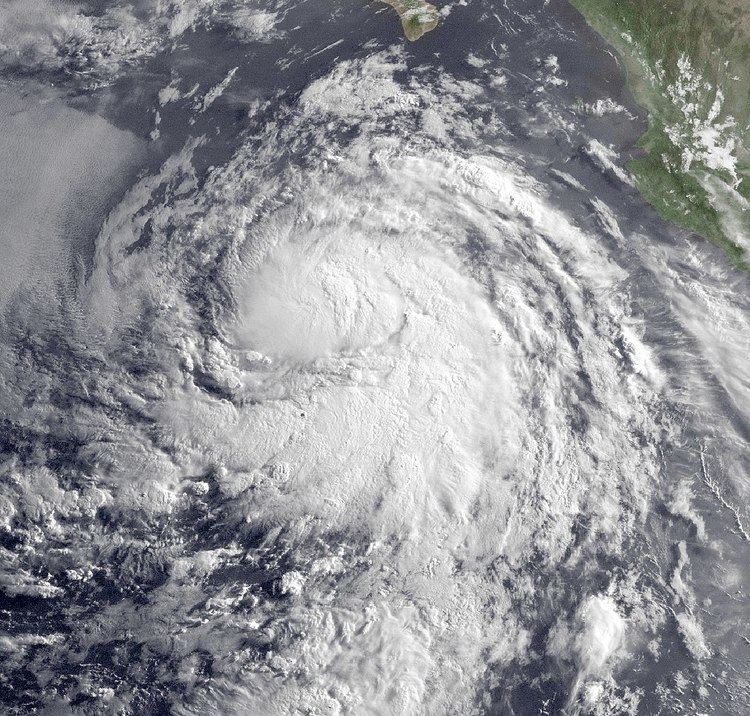
Tropical Storm Blanca originated from a tropical wave that moved off the western coast of Africa into the Atlantic Ocean on June 19. Traveling westward, the wave existed in a region of strong wind shear, preventing convective activity from developing. By June 29, the wave had crossed Central America and moved into the eastern Pacific basin. Several days later, the National Hurricane Center (NHC) began monitoring the system as a disorganized area of shower and thunderstorm activity off the southwest coast of Mexico. Early the next day, a trough of low pressure developed within the system; wind shear in the path of the storm were expected to be low enough to allow tropical cyclone development. On July 4, curved banding-features developed along the periphery of the wave, indicating that an area of low pressure had developed. Gradual organization took place over the follow days. Early on July 6, the low had become sufficiently organized to attain tropical depression strength roughly 435 miles (700 kilometres) south of Cabo San Lucas, Mexico. However, the system was not operationally declared a depression; instead, the first advisory by the NHC was issued several hours later and immediately declared the cyclone as Tropical Storm Blanca.
Upon being classified a tropical storm, Blanca had already developed an eye-feature, though it not expected to develop into a hurricane. The storm maintained a general northwestward track throughout its existence due to a mid-level ridge well to the west of the circulation. Shortly after, a central dense overcast, a large area of deep convection, developed over the center of circulation and large banding features developed along the periphery of the cyclone. Late on July 6, Blanca reached its peak intensity with winds of 50 mph (85 km/h) and a barometric pressure of 998 mbar (hPa; 29.47 inHg). Although the storm had intensified, its overall structure had deteriorated, with cloud tops warming and convection shrinking.
By July 7, most of the deep convection associated with Blanca had dissipated, and the remaining convection was confined to an outer band southeast of the center. Later that day, the system was barely holding on to tropical storm intensity as the center became devoid of shower and thunderstorm activity. A brief burst in convection allowed Blanca to maintain 40 mph (65 km/h) winds, minimal tropical storm intensity, for several more hours before being downgraded to a tropical depression.
Early on July 8, another brief burst in convection near the center of Blanca occurred. In this area, satellites found sustained winds around 40 mph (65 km/h). However, the convection quickly dissipated and the winds were not considered to be representative of the storm's true intensity. By later that day, convection had not reformed around the center of circulation and Blanca degenerated into a non-convective remnant low pressure system, corresponding with the final public advisory from the NHC. Although no longer a tropical cyclone, the remnants of Blanca maintained a well-defined low pressure center as it continued its northwesterly movement. Early on July 11, the system turned northward and gradually weakened. The following day, the remnants of Blanca dissipated over open waters.
Preparations and impact
On July 6, Mexican officials posted high seas advisories for Michoacán, Jalisco, Nayarit, Baja California Sur and Colima and advised ships to remain at port. These advisories were discontinued the following day as Blanca moved out to sea. After weakening to a tropical depression, moisture from the system enhanced a frontal system over Coahuila. The system produced upwards of 22.2 mm (0.87 in) in the span of a few hours, triggering flooding throughout the state. Numerous streets were closed due to flooding and local fire departments were deployed to assist in draining the water. No injuries or structural damage resulted from the flooding.
The remnants of the storm also brought unseasonable rainfall, although negligible, to parts of southern and central California on July 11. The moisture reached the region after being pulled northward by an upper-level low off the coast of Oregon. While over open waters, the storm produced usually heavy rainfall, exceeding 2 in/h (50 mm/h) at times.