
Formed August 13, 2005 Fatalities None reported Areas affected None | Dissipated August 14, 2005 Damage None Highest winds 56 km/h | |
 | ||
Lowest pressure 1008 mbar (hPa); 29.77 inHg Date 13 August 2005 – 14 August 2005 Similar Tropical Storm Franklin, Tropical Storm Jose, Hurricane Nate, Hurricane Irene, Tropical Storm Bret | ||
Tropical depression ten 2005
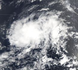
Tropical Depression Ten was the tenth tropical cyclone of the record-breaking 2005 Atlantic hurricane season. It formed on August 13 from a tropical wave that emerged from the west coast of Africa on August 8. As a result of strong wind shear, the depression remained weak and did not strengthen beyond tropical depression status. The cyclone degenerated on August 14, although its remnants partially contributed to the formation of Tropical Depression Twelve, which eventually intensified into Hurricane Katrina. Due to this, Ten is generally referred to as "the precursor to Katrina". The cyclone had no effect on land, and did not directly result in any fatalities or damage.
Contents
Tropical depression ten 2005
Meteorological history
On August 8, a tropical wave emerged from the west coast of Africa and entered the Atlantic Ocean. Tracking towards the west, the depression began to exhibit signs of convective organization on August 11. The system continued to develop, and it is estimated that Tropical Depression Ten formed at 1200 UTC on August 13. At the time, it was located about 1,600 miles (2,600 km) east of Barbados. Upon its designation, the depression consisted of a large area of thunderstorm activity, with curved banding features and expanding outflow. However, the environmental conditions were predicted to quickly become unfavorable. The depression moved erratically and slowly towards the west, and wind shear inhibited any significant intensification. Late on August 13, it was "beginning to look like Irene-junior as it undergoes southwesterly mid-level shear beneath the otherwise favorable upper-level outflow pattern". The wind shear was expected to relent within 48 hours, prompting some forecast models to suggest the depression would eventually attain hurricane status.
By early August 14, the shear had substantially disrupted the storm, leaving the low-level center of circulation exposed from the area of convection, which was also deteriorating. After meandering, the storm began to move westward. Forecasters expected it to resume a northwestward track as high pressure to the south of Bermuda was forecast to weaken and another high was predicted to form southwest of the Azores. By 1800 UTC on August 14, the strong shear had further weakened the storm, and it no longer met the criteria for a tropical cyclone. It degenerated into a remnant low, and the National Hurricane Center issued their final advisory on the cyclone. Moving westward, it occasionally produced bursts of convective activity, before dissipating on August 18.
Tropical Depression Twelve formed over the southeastern Bahamas at 2100 UTC on August 23, partially from the remains of Tropical Depression Ten. While the normal standards for numbering tropical depressions in the Atlantic stipulate that the initial designation be retained when a depression regenerates, satellite imagery indicated that a second tropical wave had combined with Tropical Depression Ten north of Puerto Rico to form a new, more complex weather system, which was then designated as Tropical Depression Twelve. In post-season reanalysis, it was found that the low-level circulation of Tropical Depression Ten had completely detached and dissipated; only the remnant mid-level circulation moved on and merged with the second tropical wave. As a result, the criteria for keeping the same name and identity were not met. Tropical Depression Twelve later became Hurricane Katrina.
Impact
Because Tropical Depression Ten never approached land as a tropical cyclone, no tropical cyclone watches and warnings were issued for any land masses. No effects, damages, or fatalities were reported, and no ships reported tropical storm-force winds in association with the depression. The system did not attain tropical storm status; as such, it was not given a name by the National Hurricane Center. The storm partially contributed to the formation of Hurricane Katrina, which became a Category 5 hurricane on the Saffir-Simpson Hurricane Scale and made landfall in Louisiana, causing catastrophic damage. Katrina was the costliest hurricane, and one of the five deadliest, in the history of the United States.