
Formed May 28, 2009 Fatalities None reported Affected area North Carolina | Dissipated May 30, 2009 Damage None Date 28 May 2009 – 30 May 2009 | |
 | ||
Highest winds 1-minute sustained: 35 mph (55 km/h)
Gusts: 45 mph (75 km/h) Lowest pressure 1006 mbar (hPa); 29.71 inHg Similar Tropical Storm Claudette, Tropical Depression Two, Tropical Storm Grace, Tropical Storm Arlene, Tropical Depression Five | ||
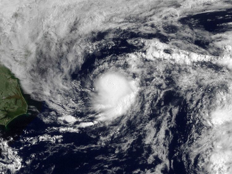
Tropical Depression One was the first tropical cyclone to develop during the 2009 Atlantic hurricane season. Upon being declared a tropical depression on May 28, it marked the third time that a pre-season storm formed in three consecutive years. Originating from a disorganized area of low pressure off the coast of North Carolina, Tropical Depression One quickly developed over the Gulf stream. After attaining winds of 35 mph (55 km/h) along with a minimum pressure of 1006 mbar (hPa; 29.71 inHg), the depression began to weaken due to increasing wind shear and cooling sea surface temperatures. During the afternoon of May 29, convection associated with the system was significantly displaced from the center of circulation; this led the National Hurricane Center to issue their final advisory on the depression as it had degenerated into a remnant-low pressure area. As a tropical cyclone, Tropical Depression One had no effects on land; however, the precursor to the depression brought minor rainfall and light winds to parts of coastal North Carolina. Its track, formation, and timing were relatively similar to Tropical Storm One of the 1940 Atlantic hurricane season.
Contents
Meteorological history
During mid-May, a frontal boundary stalled near The Bahamas and slowly degenerated. On May 25, a shortwave trough caused the northern portion of the system to move north of the Bahamas. The following day, an area of low pressure developed along the boundary about 290 miles (465 km) south-southwest of Wilmington, North Carolina. Tracking towards the north, the system became increasingly organized. On May 27, the National Hurricane Center (NHC) began issuing Tropical Weather Outlooks for the low while it was located about 120 miles (195 km) south of Cape Hatteras, North Carolina. An upper-level ridge situated to the southeast of the system was steering it towards the northeast. The NHC issued their final outlook on the low around 0000 UTC on May 28 while the system was located about 90 mi (150 km) east of Cape Hatteras, North Carolina, as development of the low was not expected.
On May 28, the NHC once again initiated outlooks on the system as convection quickly redeveloped. Around 1500 UTC, they designated the system as Tropical Depression One while it was located about 310 mi (500 km) south of Providence, Rhode Island. Upon being classified, the depression exhibited deep convective activity, with the center of circulation situated on the northwestern edge. The redevelopment of the system was the result of low wind shear and warm waters, up to 26 °C (79 °F), from the Gulf Stream. Later that day, convection began to diminish as the depression tracked into an area of progressively higher shear and cooler waters. By this time, the system was embedded within the westerlies between a subtropical ridge to the southeast and a trough to the northwest. Around 2330 UTC, a QuickSCAT satellite pass over the depression found tropical storm-force winds; however, the winds were determined to have been affected by rain and therefore not representative of the depression's actual intensity. Following the satellite pass, the center of circulation became partially exposed to the northwest and the area of convection associated with the depression diminished in area.
Early on May 29, Tropical Depression One nearly attained tropical storm status, with intensity estimates using the Dvorak Technique reaching T2.5, or 40 mph (65 km/h); however, the estimates were also as low as T1.5, leading to the intensity of the depression remaining at 35 mph (55 km/h). After a burst in convective activity overnight, shower and thunderstorm activity waned once more by 0700 UTC. Situated at the edge of the Gulf Stream, intensification into a tropical storm was no longer anticipated. Later that morning, the center of circulation became fully exposed by strong wind shear; an approaching trough also began absorbing the small depression by this time. The remaining convection associated with the system was displaced to the southeast. With no convection developing around the depression, it degenerated into a remnant-low pressure area during the afternoon of May 29. At 2100 UTC, the NHC issued their final advisory on Tropical Depression One. The remnants of the depression persisted until 0600 UTC on May 30, at which time it was absorbed by a warm front south of Nova Scotia.
Preparations, impact and records
The precursor to Tropical Depression One produced light showers over parts of North Carolina on May 27. Rainfall in Hatteras amounted to 0.1 in (2.5 mm) on May 27; sustained wind reached 15 mph (24 km/h) and gusts were measured up to 23 mph (37 km/h). The lowest sea level pressure recorded in relation to the system was 1009 mbar (hPa; 29.81 inHg). Increased winds along coastal areas of the state was possible in relation to the outer edges of the depression. Tropical Depression One was the farthest north a May tropical cyclone is known to have formed, according to the NHC's Tropical Cyclone Report.