
Area 88 ha Local time Saturday 9:55 AM | Elevation 561 m Population 103 (2002) | |
 | ||
Weather 7°C, Wind E at 10 km/h, 70% Humidity | ||
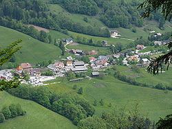
Trojane ([tɾɔˈjaːnɛ]; Latin: Atrans, German: Trojana) is a settlement in the Municipality of Lukovica in central Slovenia. It lies in the northern part of the Sava Hills, on a hill near the border of two Slovene regions, Carniola and Styria. Until the freeway was finished in 2005, Trojane was on the main route from Ljubljana to Maribor.
Map of 1222 Trojane, Slovenia
The Romans built a road on the route connecting Aquileia, Emona, Atrans, and Celeia. Trojane was an important way station, military post, and marketplace, and the town was surrounded by a defensive wall.
The archaeological remains of Atrans can be still seen in Trojane. In the Roman Empire, Trojane (Atrans) was on the border between Italy and the province of Noricum.
Trojane is particularly known for the local restaurant's filled doughnuts (Slovene: krofi), originally made with apricot jam filling.