
Country United States FIPS code 37-68400 Elevation 244 m Population 6,658 (2013) Area code 336 | Time zone Eastern (EST) (UTC-5) GNIS feature ID 0996229 Zip code 27370 Local time Friday 9:26 PM | |
 | ||
Weather 16°C, Wind S at 6 km/h, 61% Humidity Area 44.03 km² (43.77 km² Land / 26 ha Water) | ||
Trinity is a city in Randolph County, North Carolina, United States. The population was 6,614 at the 2010 census.
Contents
Map of Trinity, NC, USA
History
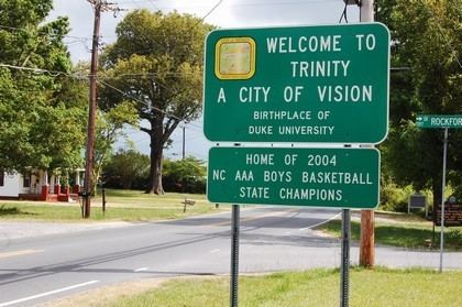
The community was named after Trinity College, which later became Duke University. The "World's Longest Hot Wheels Track" was built at the Kyle Petty Farm in Trinity, North Carolina, on May 9, 1999. Sealy Corporation, the world’s largest manufacturer of bedding products with sales of $1.2 billion in 2003, is headquartered in Trinity, North Carolina. Former baseball player Gil English died in Trinity, North Carolina. Trinity is also home to NASCAR Sprint Cup Series drivers Bobby Labonte, Brian Vickers and Kyle Petty..
Trinity College, later Duke University, started as Brown's Schoolhouse, a private subscription school founded in 1838. The school was organized by a group of Methodists and Quakers, and was officially started by Hezekiah Leigh; the same Leigh who is widely recognized as the founder of Randolph-Macon College. In 1841 North Carolina issued a charter for Union Institute Academy. The school took the name Trinity College in 1859, and in 1892, Trinity moved to Durham.
Geography
Trinity is located at 35°52′25″N 80°0′37″W (35.873522, -80.010158).
According to the United States Census Bureau, the city has a total area of 17.0 square miles (44 km2), of which, 16.9 square miles (44 km2) of it is land and 0.1 square miles (0.26 km2) of it (0.59%) is water.
Demographics
As of the census of 2000, there were 6,690 people, 2,638 households, and 2,057 families residing in the city. The population density was 395.9 people per square mile (152.8/km²). There were 2,759 housing units at an average density of 163.3 per square mile (63.0/km²). The racial composition of the city was: 93.05% White, 5.04% Black or African American, 0.91% Hispanic or Latino American, 0.54% Asian American, 0.63% Native American, 0.01% Native Hawaiian or Other Pacific Islander, 0.33% some other race, and 0.40% two or more races.
There were 2,638 households out of which 30.5% had children under the age of 18 living with them, 63.3% were married couples living together, 10.4% had a female householder with no husband present, and 22.0% were non-families. 18.3% of all households were made up of individuals and 6.7% had someone living alone who was 65 years of age or older. The average household size was 2.54 and the average family size was 2.86. Trinity has a low rate of studio and one bedroom rentals compared to many cities. Trinity also a low rate of people living alone.
In the city, the population was spread out with 22.5% under the age of 18, 6.9% from 18 to 24, 29.1% from 25 to 44, 29.7% from 45 to 64, and 11.8% who were 65 years of age or older. The median age was 40 years. For every 100 females there were 97.7 males. For every 100 females age 18 and over, there were 94.8 males.
The median income for a household in the city was $43,277, and the median income for a family was $48,838. Males had a median income of $35,498 versus $22,208 for females. The per capita income for the city was $21,068. About 6.1% of families and 8.6% of the population were below the poverty line, including 12.0% of those under age 18 and 12.0% of those age 65 or over.
Education
Randolph County School System operates public schools including Trinity High School.