
Airport type Public Elevation AMSL 193 ft / 59 m 4,005 1,221 Phone +1 209-831-6262 | 7/25 4,005 Elevation 59 m Owner Tracy City Hall | |
 | ||
Operator FBO SkyView Aviation LLC Address 5749 S Tracy Blvd, Tracy, CA 95377, USA Similar Stockton Metropolit Airport, Tracy, Liver Municipal Airport, Tri Valley Airporter | ||
Tracy Municipal Airport (ICAO: KTCY, FAA LID: TCY) is three miles (5 km) southwest of Tracy, in San Joaquin County, California. It is owned by the City of Tracy.
Contents
Most U.S. airports use the same three-letter location identifier for the FAA and IATA, but Tracy Municipal Airport is TCY to the FAA and has no IATA code.
Facilities
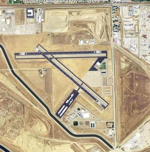
Tracy Municipal Airport covers 310 acres (130 ha) and has two asphalt runways, 7/25 & 12/30, each 4,000 x 100 ft (1,220 x 30 m).
In the year ending July 17, 2005 the airport had 60,000 aircraft operations, average 164 per day: 99% general aviation and 1% air taxi. 122 aircraft are based at the airport: 95% single engine, 3% multi-engine and 2% ultralight.
World War II
During World War II the airport was Tracy Auxiliary Airfield (No 4), and was an auxiliary training airfield for Stockton Army Airfield, California.