
Country Japan Region ChubuHokuriku Population 421,953 (2010) | Area 1,241.85 km2 | |
 | ||
Colleges and Universities University of Toyama, Toyama University of International Studies, Toyama National College of Maritime Technology, Toyama National College of Technology, Toyama College | ||
Mayor Masashi Mori (since January 2002) | ||
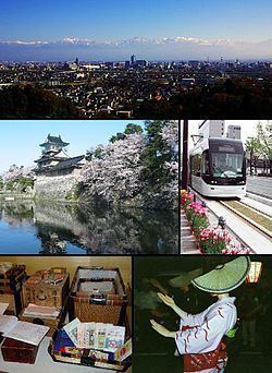
Map of Toyama, Toyama
Toyama (富山市, Toyama-shi, [tóꜜyàmà]) is the capital city of Toyama Prefecture, Japan, located on the coast of the Sea of Japan in the Chūbu region on central Honshū, about 200 km (120 mi) north of the city of Nagoya and 300 km (190 mi) northwest of Tokyo.
Contents
- Map of Toyama Toyama
- Toyama japan
- Geography
- Surrounding municipalities
- Climate
- Early history
- Recent history
- 2005 mergers
- Economy
- Colleges and universities
- Primary and secondary education
- Airports
- Railway
- Highway
- International relations
- Local attractions
- Festivals and events
- References
As of 1 October 2016, the city had an estimated population of 418,142 and a population density of 337 persons per km². Its total area was 1,241.77 square kilometres (479.45 sq mi).
The city has been designated an environmental model city by the national government for its efforts to reduce the emission of greenhouse gases.
Toyama japan
Geography
Located in the middle of its prefecture, Toyama is a seaside city by the coast of the Sea of Japan. Its municipal territory borders with the Gifu Prefecture and with the municipalities of Imizu, Namerikawa, Tonami, Nanto, Hida and Takayama.
The nearest towns are Imizu (west), and Namerikawa (east), both by the sea and part of the Toyama urban area. The nearest city is Kanazawa, the capital of Ishikawa Prefecture, which is 65 km (40 miles) away.
Surrounding municipalities
Climate
Toyama has a humid subtropical climate (Köppen climate classification Cfa) with hot, humid summers and cool winters. Precipitation is abundant throughout the year, particularly in July, September and from November through January. Despite winter in Toyama being relatively mild, its position near the Sea of Japan places it within the heavy snow belt of Japan and on average 3.8 m (12 ft) of snow falls each season, almost all of it from December through March, as well as occasionally experiencing some tremendous amounts of snowfall.
Early history
The area of present-day Toyama city was part of ancient Etchū Province. The Toyama Plain is good farmland and historically it was a point of strategic and traffic importance since prehistoric times. During the Sengoku period, it was frequently a battlefield, coming under the control of warlord Sasa Narimasa, who built a castle town around Toyama Castle and channeled rivers to bringing about a flourishing agricultural industry. The area subsequently became part of Kaga Domain under the Maeda clan during the Edo Period, during which time a positive industrial promotion policy was implemented on the production of Chinese medicine and washi (Japanese paper). Also, thanks to the improvement of kitamaebune sea transportation routes, these industries thrived and Toyama became known nationwide as the province of medicine.
Recent history
After the Meiji Restoration, with the creation of the municipalities system, the city of Toyama was established on April 1, 1889 as one of the first 30 cities in Japan. Economically, the area developed heavy and chemical industries based on abundant hydroelectric electricity. Toyama has become one of the most influential cities on the Sea of Japan with its good water supply, drainage system and thriving agricultural, forestry, fishery, commercial and manufacturing industries. During World War II, Allied POWs were sent to Toyama as forced labor.
The city was almost completely destroyed on the night of August 1–2, 1945. At the time of the bombing, the city was a center for aluminum, ball-bearing and special steel production. The city during the time had a population of around 150,000 residents.
2005 mergers
On April 1, 2005, the towns of Ōsawano and Ōyama (both from Kaminiikawa District), the towns of Fuchū and Yatsuo, and the villages of Hosoiri and Yamada (all from Nei District) were merged into Toyama. Kaminiikawa District and Nei District were both dissolved as a result of this merger.
Economy
Hokuriku Electric Power Company (colloquially known as Hokuden), the regional power-supply monopoly, is based in Toyama. Bearing parts and industrial robot company Nachi-Fujikoshi and software company INTEC are also headquartered in Toyama.
Regional banks include Hokuriku Bank, First Bank of Toyama, and Toyama Bank.
Colleges and universities
Primary and secondary education
Toyama has 65 public elementary schools and 26 public middle schools operated by the city government. There is also one public elementary school and one public middle school operated by the national government. The city has fourteen public high schools operated by the Toyama Prefectural Board of Education. and one public combined middle/high school operated by the national government. There are also seven private high schools