
Legislature House of Commons First contested 1935 District webpage profile, map Census division Toronto | District created 1933 Last contested 2015 Province Ontario Elector 75,852 | |
 | ||
MP Carolyn Bennett
Liberal | ||
Toronto—St. Paul's is a federal electoral district in Toronto, Ontario, Canada, that has been represented in the Canadian House of Commons since 1935. Its current MP is Carolyn Bennett. Prior to the 2015 election, the riding was known as St. Paul's.
Contents
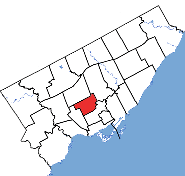
The small but densely populated riding covers the area to the north of Downtown Toronto. In the past, it had been considered a bellwether riding, having been represented by only three opposition MPs. However, like most Toronto-based ridings, the Liberals have dominated recent elections. Since the Liberals won all but one seat in Ontario in their 1993 landslide, they have won all but one election in St. Paul's by 10,000 votes or more.
Demographics
According to the Canada 2006 CensusEthnic groups: 76.08% White, 5.31% Black, 4.04% Filipino, 3.73% Chinese, 2.85% Latin American, 2.46% South Asian
Languages: 67.47% English, 1.87% French, 30.47% Others
Religions (2001): 29.28% Catholic, 25.01% Protestant, 19.60% Non religious, 14.03% Jewish, 4.18% Christian Orthodox, 2.62% Other Christian, 2.52% Muslim, 1.35% Buddhist
Average income: $34,617
History
It was created in 1933 from parts of Toronto East Centre, Toronto Northeast, Toronto South and Toronto West Centre ridings.
It consisted initially of the central part of the City of Toronto. It was bounded on the south by Toronto Bay, on the east by Sherbourne Street and on the north and west by a line drawn from Sherbourne Street west along Bloor Street, north along Yonge Street, northwest along the belt line railway, south and west along the western limit of the city, south along Dunvegan Road, east along St. Clair Avenue, south along Poplar Plains Road, west along Dupont Street, south along St. George and Beverley Streets, east along Queen Street, south along John Street.
In 1947, it was redefined to consist of the part of the city of Toronto bounded on the south by Toronto Bay, on the east by a line drawn from the Bay north along Sherbourne Street, west along Bloor Street East and north along Yonge Street, on the north by the south boundary of Ward Nine of the city of Toronto, and on the west by a line drawn from the Bay north on John Street, west along Queen Street West, north on Beverley Street and along St. George Street, east along Dupont Street, north along Davenport Road and Poplar Plains Road, west along St. Clair Avenue West, north along Dunvegan Road, east and north along the city limit to the southern boundary of Ward Nine.
In 1966, it was redefined to consist of the part of Metropolitan Toronto bounded by a line drawn from Bloor Street, north along Yonge Street, northwest along the Canadian National Railway line, north along Elmsthorpe Avenue, west along Eglinton Avenue, north along Castlewood Road, west along Briar Hill Avenue, south along Old Park Road and Glen Cedar Road, southeast along Claxton Boulevard, south along Bathurst Street and east along Bloor Street to Yonge Street.
In 1987, it was redefined to consist of the part of the cities of Toronto and York bounded by a line drawn from the Canadian Pacific Railway line north along Ossington Avenue, east along Davenport Road, north along Winona Drive, west along Eglinton Avenue West, north and east along the eastern limit of the City of York, east and north along the northern limit of the City of Toronto, south along Yonge Street and westerly along the CPR line to Ossington Avenue.
In 1996, it was redefined to consist of the part of the cities of Toronto and York bounded by a line drawn from the Canadian Pacific Railway north along Ossington Avenue, east along Davenport Road, north along Winona Drive, west along Eglinton Avenue West, north along the eastern limit of the City of York, east along the northern limit of the City of Toronto, south along Bathurst Street, southeast along the Belt Line (formerly the Canadian National Railway), east along Eglinton Avenue West, north along Yonge Street, east along Broadway Avenue, south and east along the eastern limit of the City of Toronto, west along the south side of the Mount Pleasant Cemetery, south along the ravine situated east of Avoca Avenue, west along Rosehill Avenue, south and east along the west side of the Rosehill Reservoir, west along Woodlawn Avenue East, south along Yonge Street, and west along the Canadian Pacific Railway to Ossington Avenue.
In 2003, it was redefined to consist of the part of the City of Toronto bounded by a line drawn from the Canadian Pacific Railway north along Ossington Avenue, east along Davenport Road, north along Winona Drive, west along Holland Park Avenue, north along Oakwood Avenue, west along Rogers Road, north along Dufferin Street, east along Eglinton Avenue West, north along Yonge Street, east along Broadway Avenue, south along the former eastern limit of the City of Toronto, west along the south side of the Mount Pleasant Cemetery, southeast along the Don River Tributary situated east of Avoca Avenue, west along Rosehill Avenue, south along the west side of the Rosehill Reservoir, west along Jackes Avenue, south along Yonge Street and west along the Canadian Pacific Railway to Ossington Avenue.
In the 2012 electoral redistribution, St. Paul's lost territory to Don Valley West, gained a small fraction from Davenport and was renamed Toronto—St. Paul's.
Members of Parliament
This riding has elected the following Members of Parliament:
St. Paul's, 1935–2015
*Comparison to total of Progressive Conservative and Canadian Alliance vote in 2000.
Note: Canadian Alliance vote is compared to the Reform vote in 1997 election.
Note: NDP vote is compared to CCF vote in 1958 election.
Note: Progressive Conservative vote is compared to "National Government" vote in 1940 election.
Note: "National Government" vote is compared to Conservative vote in 1935 election.