
Type Tornado outbreak Max rating Start date January 1999 | Duration January 21–23, 1999 Duration of tornado outbreak 46 hours Damage 90.5 million USD | |
 | ||
Tornadoes confirmed 127 confirmed
(Record for a tornado outbreak in January) Casualties 9 fatalities, 162 injuries | ||
The January 21–23, 1999 tornado outbreak was the largest tornado outbreak on record during January took place across the Mississippi River Valley. Over the course of roughly two days, 127 tornadoes touched down across the region, resulting in widespread damage. Nine people were killed by the tornadoes. The outbreak is best known for an F3 that struck Little Rock, Arkansas, killing three people.
Contents
Meteorological synopsis
On January 21, the Storm Prediction Center (SPC) issued a High risk of severe weather across much of central and eastern Arkansas, southwestern Tennessee, northeastern Louisiana, and much of northern and western Mississippi. The organization warned of the potential for a widespread severe weather outbreak, including several long-tracked and intense tornadoes. The meteorological setup unfolded as a broad upper-level trough, with its axis across the Central United States, rapidly amplified in conjunction with a 175 mph (280 km/h) jet streak across the southern Rockies. Substantial height falls—implying cooling in the mid layers of the atmosphere—coupled with the sharpening trough allowed for strong divergence to overspread the highest risk area. At the surface, a deepening area of low pressure initially centered near the Texas–Oklahoma border early on January 21 deepened and accelerated eastward, reaching the Arkansas–Missouri border during the overnight hours. A dry line extended southward across eastern Texas, providing increased mechanisms for rising air as it combined with a cold front and pushed eastward into Arkansas.
As the upper-level trough rapidly intensified, 500mb winds increased to 70–80 mph (110–130 km/h) and 850mb winds topped 70 mph (110 km/h) across the High risk area. The combination of speed shear and adequate directional shear (noted by curved low-level hodographs) led to 0–3km storm relative helicities of 300–500 m2/s2, favorable for rotating thunderstorms. A capping inversion, qualified by cold and dry air aloft, initially prevented the formation of thunderstorms and instead allowed substantial surface heating. Surface-based CAPE values of 1500–2000 j/kg and most unstable CAPE values of 1000–2000 j/kg became prevalent across the broad warm sector. Low-level moisture transported northward from the Gulf of Mexico resulted in dewpoints in the low- to mid-60s °F by the afternoon hours. With continually strengthening wind fields, the capping inversion steadily weakened, and several tornadic supercells formed across Arkansas. In addition to the tornado outbreak, steep 850–500mb lapse rates, ranging from 6.5–7.5 c/km, contributed to a favorable environment for gigantic hail and widespread damaging winds. Nine reports of hail over 2.51 in (6.38 cm) were received by the SPC.
Little Rock, Arkansas tornadoes
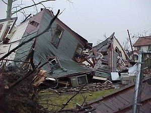
The Little Rock area was slammed by a strong tornado on the evening of January 21. The tornado began in Saline County south of Vimy Ridge at 6:24 pm CST (0024 UTC). Before crossing the Pulaski County line, it did moderate damage to several houses and significant damage to a mobile home. It crossed into Pulaski County at 6:33 pm, where moderate roof damage was reported to several buildings along the Interstate 30 corridor. It continued eastward and did most of its devastation just south of the downtown area.
There was severe damage reported to over 235 buildings, many of which were destroyed. One of the destroyed buildings included a large grocery store, a Harvest Foods, where one person was killed. Over 500 other buildings sustained lesser damage. Some of the houses damaged that were in the historic district were also condemned due to there being lead smelt beneath them. Trees and power lines were also knocked down throughout the area. Damage was also reported on the property of the Arkansas Governor's Mansion, where many trees were knocked down. As the tornado left the downtown vicinity, it weakened as it crossed Interstate 40. It weakened in the northeastern suburbs, near Sherwood at 6:53 pm CST, after being on the ground for 29 minutes and travelling 22 miles (35 km). The first tornado was rated as an F3 tornado on the Fujita scale
As the first tornado dissipated, a second tornado developed in eastern Pulaski County. While it remained in more rural settings, it also destroyed several buildings, including a storage facility. It also knocked over several tractor-trailers before crossing into Lonoke County. Extensive damage was also reported in Lonoke County, where the South Bend community was hit hard. 12 houses, 11 mobile homes and several farm buildings were damaged or destroyed in Lonoke County. The tornado dissipated at 7:02 pm CST (0102 UTC) southwest of Cabot. It was an F2 tornado.
Three people died in the tornadoes (all due to the first F3). One of them was in the destroyed grocery store, another was in a vehicle hit by a tree, and the third was in a mobile home that was destroyed. 78 other people were injured by the tornado.