
Type Tornado outbreak Tornadoes confirmed 55 confirmed Duration of tornado outbreak 19 hours | Duration April 26, 1991 Max rating Start date April 26, 1991 | |
 | ||
Highest winds ~268 mph (431 km/h) tornadic winds from the Red Rock tornado Similar 1999 Oklahoma tornado o, 1985 United States–C, 1974 Super Outbreak, 1999 Bridge Creek–M, Tri‑State Tornado | ||
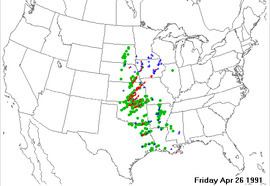
The April 26, 1991 tornado outbreak was a violent outbreak of 55 tornadoes that took place on April 26, 1991 in the Central and Southern Great Plains, killing 21 people and injuring hundreds more.
Contents
Meteorological synopsis
On April 25, 1991, the National Severe Storms Forecast Center, now called the Storm Prediction Center, forecast a high risk of severe weather for the following day. A strong storm system was due to move through the area the next afternoon and evening of April 26, 1991.
Confirmed tornadoes
(based on NOAA Storm Data)
Haysville–McConnell AFB–Andover, Kansas
This long-tracked tornado reached a powerful F5 status and was the most destructive tornado of the entire outbreak. It is considered one of the most-filmed F5 tornadoes of all time, because by 1991, video camcorders were very popular and easily obtainable by the general public. The Andover tornado was filmed from many different angles throughout its life.
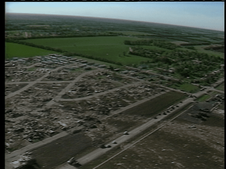
It first produced extensive damage as it formed south of Clearwater, Kansas. It fluctuated in intensity near the beginning of the path, and then moved through the north side of the city of Haysville, near 63rd Street South and Meridian. Widespread damage was reported in Haysville with many structures destroyed, but there were no fatalities. The tornado entered Wichita city limits near 56th Street South and Broadway/US-81, crossed the Kansas Turnpike at the overpass over 55th Street South. The tornado expanded to around 300 feet wide as it crossed I-35 (the Kansas Turnpike), destroyed a plant nursery at 53rd Street South and Hydraulic Street, and headed toward McConnell Air Force Base. Many people had advance warning before the tornado struck McConnell AFB. The tornado struck the base school, hospital and housing as an F3 tornado. It caused $62 million in damage on the base, narrowly missing a multibillion-dollar line of B-1 bombers. The damage path widened dramatically as the tornado intensified just east-northeast of the base.
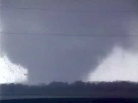
By 6:35 p.m., the tornado had expanded to just over 600 yards wide and was approaching maximum intensity. It continued to move northeast exiting the Wichita metro area and reached F5 intensity as it tore through the town of Andover, Kansas. Thirteen people were killed as the Golden Spur Mobile Home Park was obliterated, with little left there but scattered debris and twisted mobile home frames. The death toll included a father and son who abandoned their car and sought shelter in a ditch nearby. Extensive wind-rowing of debris and grass scouring was noted as the tornado swept large, well-constructed homes with anchor bolts cleanly from their foundations just west of N Andover Road as the tornado passed through densely populated residential areas. Vehicles were thrown nearly a mile from where they originated, and trees in the area were completely debarked. One vehicle that originated at the Golden Spur mobile home park was thrown 3/4 of a mile, and was so thoroughly mangled that surveyors could not determine if it was a car or a truck. The tornado then veered north, missing a Girl Scout camp where summer camp training was being conducted and a troop campout. The tornado then moved on to the northeast, passing just south of Towanda. The damage in this area was rated at F4 intensity as additional well-built homes were leveled. The tornado continued northeast and reached El Dorado Lake just before 7pm (CST). Video taken by local storm chasers shows that the tornado crossed over the lake and revealed a multiple vortex structure. Just after crossing over the lake to the northeast, the circulation dissipated and died out. The Andover tornado had traveled for nearly 46 miles, and was on the ground for over an hour.
This was the last F5 tornado recorded in Kansas under the old Fujita scale. The next tornado of such intensity, an EF5 on the newer Enhanced Fujita scale, wouldn't be reported until 16 years later on May 4, 2007, in Greensburg, Kiowa County, about 120 miles west of the path of the 1991 tornado. Since February 1, 2007, the National Weather Service has used the Enhanced Fujita scale.
El Dorado Lake/Kansas Turnpike Underpass, Kansas
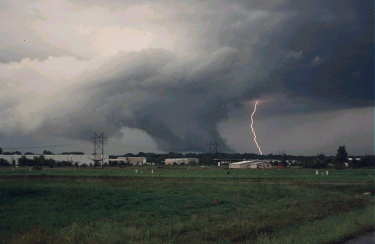
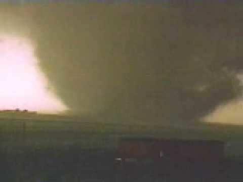
The new tornado moved northeast from the edge of El Dorado Lake toward Cassoday. A news team from KSNW-TV in Wichita was returning to the station along the Kansas Turnpike from a story unrelated to the tornado. Reporters Ted Lewis and Greg Jarrett soon encountered a tornado, and decided to try to shoot video of the storm. However, the tornado veered and began following the crew along the highway at a speed faster than they could drive. They reached an overpass where several people had already abandoned their cars. The cameraman advised the other people that they should all get into the very upper part of the overpass, thinking that this would shield them from the wind. The cameraman recorded the entire chain of events as the tornado passed nearby, tossing the van and throwing debris. The overpass itself did not receive a direct hit from the tornado, but it appeared to on camera as the tornado passed just behind the cameraman's location. It lasted approximately 20 seconds. The tornado then continued northeast and dissipated at about 7:30 p.m., just northeast of the Cassoday Interchange of the Kansas Turnpike. All the cars parked under the underpass had their windows blown out. Other cars and tractor-trailers on the turnpike (hit by the tornado) rolled multiple times or were tossed from the roadway, injuring four people.
Due to the popularity of the news team's video, in which they are depicted surviving by using an overpass for shelter, overpasses are now frequently jammed with people seeking shelter during tornado activity. Such was the case in many areas during the 1999 Oklahoma tornado outbreak, in which some people left the safety of their homes when the tornado warning was issued to take shelter under overpasses. One tornado hit three underpasses and killed people at each one. It is now believed that highway overpasses provide little, if any, protection from tornadic winds, and the National Weather Service strongly advises against using overpasses for shelter. An overpass is an extremely dangerous spot to be in a tornado, especially if it does not have the open girder design like that in the video. Using underpasses as protection does little more than raise people above ground level, exposing them to higher winds and more debris. Additionally, the wind speed may be increased by the wind tunnel effect. Another danger is the sheer number of people now congregating at underpasses blocks traffic, which has hindered emergency responders. Moreover, it presents the danger that an intense tornado will hit people taking shelter as well as bystanders stuck in traffic, who are massed in a vulnerable location incurring the possibility of a significant death toll.
Red Rock, Oklahoma
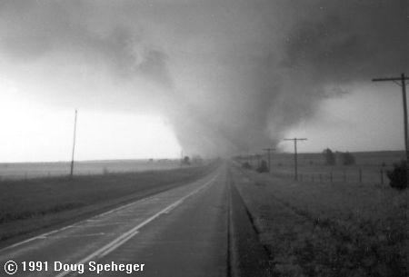
South of Wichita, in Garfield County, Oklahoma, tornado chasers (including Warren Faidley, Gene Moore, Howard Bluestein, KJRH-TV meteorologist Gary Shore and many other chasers) observed the touchdown of what would be the longest-tracked tornado of the outbreak. The tornado began 2.5 miles east of Garber, and then grew into a large 3/4 mile wide wedge as it passed south of Billings, destroying a house. As the tornado passed near Ceres, two farms were destroyed. In rural areas of Noble County, trees were debarked and pavement was scoured off of several county roads. The tornado then crossed into Osage County, uprooting trees and damaging another house as it passed near Fairfax. At least one home was completely demolished, leaving no walls standing (indicating F4 damage). At one point, a University of Oklahoma chase team used a portable Doppler weather radar to measure a wind speed of up to 268 mph in the funnel, indicating that winds reached F5 intensity within the tornado. However, these readings were taken near the top of the funnel, indicating that these winds may not have reached ground level. At the time, this was the fastest wind speed ever measured on Earth (it has now been surpassed by a tornado near Bridge Creek in Central Oklahoma on May 3, 1999, which produced a 1/4 mile gust of 301 mph). A large oil rig was toppled before the tornado lifted in central Osage County, after having traveled for 66 miles and injuring six people. It encountered few man-made structures along its path, making it difficult for storm survey teams to rate. It was given an F4 rating.
Aftermath
The 1991 outbreak was featured in two different documentaries: the first one was Enemy Wind, a documentary produced by The Weather Channel. It was also covered in Cyclone, a documentary that was produced and distributed by National Geographic, which released this one and dozens of other documentaries under its National Geographic Home Video series, and were released in both VHS and DVD formats.