
Primary inflows Basin countries Switzerland Surface elevation 2,345 m Outflow location Rein da Tuma | Primary outflows Rein da Tuma Surface area 2.5 ha (6.2 acres) Area 2 ha Inflow source Rein da Tuma | |
 | ||
Similar Sources of the Rhine, Oberalp Pass, Piz Badus, Alps, Vorderrhein | ||
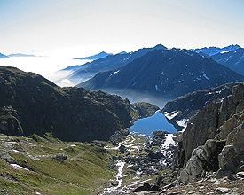
Tomasee (Romansh: Lai da Tuma or Lag da Toma) is a lake at the northern face of Piz Badus, above the village of Tschamut in Grisons, Switzerland. Its surface area is 2.5 ha (6.2 acres).
Map of Tomasee, 7189 Tujetsch, Switzerland
It is the source of the Anterior Rhine and is deemed to be the official source of the Rhine (the source of the Posterior Rhine is above Hinterrhein, Switzerland, at 46.499°N 9.065°E / 46.499; 9.065 (Source of Hinterrhein)).
It is possible to reach the lake on a path from Oberalp Pass, suitable for most walkers although still a mountain trail.
References
Tomasee Wikipedia(Text) CC BY-SA