
Basin size 3,375 km (1,303 sq mi) Discharge 4.28 m³/s Country Italy | Length 152 km Mouth Gulf of Oristano Mouth elevation 0 | |
 | ||
Main source Punta Pianedda (Buddusò) plateau
985 m (3,232 ft) River mouth Gulf of Oristano
0 m (0 ft) Provinces Province of Nuoro, Province of Sassari, Province of Oristano Similar Goceano, Nuraghe, Punta La Marmora, Montiferru, Santa Giusta Cathedral | ||
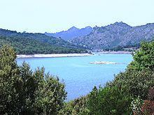
The Tirso (Sardinian: Tirsu, Latin Thyrsus) is a 152-kilometre (94 mi) river, the most important of the island of Sardinia (Italy). It rises from the plateau of Buddusò, on the slopes of the Punta Pianedda at an elevation of 985 metres (3,232 ft) and crosses the island from east to west, passing through Lake Omodeo and entering the sea in the Gulf of Oristano.
Map of Tirso, Italy
References
Tirso (river) Wikipedia(Text) CC BY-SA