
Population 534 (2006 census) Postal code 4376 | Postcode(s) 4376 Elevation 924 m Local time Friday 8:37 PM | |
 | ||
Weather 15°C, Wind E at 13 km/h, 79% Humidity | ||
Thulimbah is a town in the Southern Downs region of Queensland, Australia. The town is located on the New England Highway and in the Southern Downs Region local government area, 206 kilometres (128 mi) from the state capital, Brisbane. At the 2006 census, Thulimbah and the surrounding area had a population of 534.
Contents
Map of Thulimbah QLD 4376, Australia
History
The name of the town derives from the name of the railway station used from 1883, apparently meaning "place of water" in an unrecorded Aboriginal language.
Thulimba State School opened 29 September 1914.
There was originally another district in Queensland called Thulimbah, which was a source of confusion to many people. Eventually the problem was resolved in 1916 by renaming the other district Barney View (due to its location beside Mount Barney).
Economy
Thulimba is a fruit-growing area, including apples, pears, cherries, grapes and oranges for both table and wine-making. There are a number of wineries, many with cellar door outlets in the area. Other local food producers also offer tastings, sales and cafe menus.
Attractions
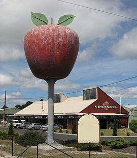
The town is home to one of Australia's big things, a tourist attraction known as the "Big Apple".