
Population 8,115 (2011 census) | Postcode(s) 2120 Postal code 2120 | |
 | ||
Federal divisions Division of Berowra, Division of Bradfield | ||
Thornleigh is a suburb of Sydney, in the state of New South Wales, Australia 25 kilometres (16 mi) north-west of the Sydney central business district in the local government area of Hornsby Shire. Thornleigh is bounded to the north by Waitara Creek. Thornleigh borders the suburbs of Normanhurst, Westleigh, Hornsby, Wahroonga and Pennant Hills. It is considered part of the Northern Suburbs of Sydney.
Contents
- Map of Thornleigh NSW 2120 Australia
- History
- Transport
- Commercial areas
- Schools
- Population and demographics
- Sport
- References
Map of Thornleigh NSW 2120, Australia
Thornleigh offers great district views and the topography varies greatly with many properties built around bushland settings and into the hills to afford the great views. Top streets are considered the top of Tillock Street and Wanawong Drive for some of the suburbs best views and proximity to the train station.
History
The first non indigenous people to explore the area of Thornleigh were a party led by Governor Arthur Phillip in 1788. Settlers moved into the area in the 1830s and among them were James Milson, Patrick Duffy, John Thorn and Samuel Horne.
Thornleigh is named after Constable John Thorn, who, along with Constable Horne, captured bushrangers Dalton and John MacNamara, leader of the North Rocks gang, on 22 June 1830, and were granted land as a reward in 1838. Horne's land became Hornsby, and Thorn's land became Thornleigh. The railway line was built in the 1880s and development followed.
Thornleigh Post Office opened on 12 March 1888.
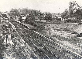
As part of the construction of the railway from Strathfield to Hornsby, a 1.2km branch was constructed in 1884 by the contractors to a quarry in a gully west of Thornleigh. The tracks included a zig zag section.
In 1901, the National Brickworks started operations at Thornleigh. In 1913, the largest malt works in the southern hemisphere was established by WG Chilvers.
During the Great Depression of the 1930s, unemployment was a problem in the area, so a local woman named Lorna Brand raised money for the construction of a walking track near the Lane Cove River as a way of providing relief work. The track begins at Thornleigh Oval, at the bottom of Handley Avenue, and goes through the bush towards the Lane Cove River. It then goes parallel to the river for a short distance before looping back to arrive at Comenarra Parkway. An extension goes down to the river, through a spot called Conscript Pass. At this spot, there are rock carvings done by the men who worked on the track. One of the carvings is a caricature of Bertram Stevens, Premier of New South Wales from 1932 to 1939. The track is known as Lorna Pass in memory of Lorna Brand, and is now part of the Great North Walk, a long-distance walking trail between Sydney and Newcastle.
Transport
Thornleigh railway station is on the North Shore, Northern & Western Line of the Sydney Trains network. Pennant Hills Road is part of the National Highway, and is one of Sydney's major thoroughfares. The Esplanade from Pennant Hills is a main road accessing Thornleigh to Normanhurst.
Commercial areas
Thornleigh contains industrial and commercial areas. Thornleigh Marketplace containing a supermarket and speciality stores was constructed in 2005. Shops and restaurants are located around Thornleigh railway station and nearby Pennant Hills Road. American multinational fast food restaurant chain McDonald's have their Australian headquarters in Thornleigh.
Schools
Population and demographics
At the 2011 census, the population of Thornleigh in 2011 was 8,115 people. Of these:
Sport
The local sports clubs include the Thornleigh Sport and Recreation Club with baseball, basketball, cricket, netball, soccer and softball divisions. The soccer club known as Thunder FC consists of teams ranging from Under 6s through to All Age divisions playing in the Gladesville Hornsby Football Association. Home grounds are Oakleigh Oval and Ruddock Park. The Brickpit Park is used for Basketball, Golf driving range, skateboarding and other passive recreational activities. Thornleigh Squash Centre has 9 glass backed courts.