
Type Mountain glacier Terminus Rock ledge | Length .10 mi (0.16 km) Status Retreating | |
 | ||
Area Approximately 42 acres (0.17 km) in 2005 Similar Glacier National Park, Gem Glacier, Swiftcurrent Glacier, Old Sun Glacier, Chaney Glacier | ||
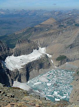
The Salamander Glacier is in Glacier National Park in the U.S. state of Montana. The glacier lies on a shelf on the east side of the arête which is part of the Continental Divide, at an average elevation of 7,200 feet (2,200 m) above sea level. The Salamander Glacier covered an area of approximately 57 acres (0.23 km2) as of 1993. Before Grinnell Glacier retreated significantly, it used to encompass The Salamander Glacier and the two become separate sometime before 1929. The Salamander Glacier was measured at 42 acres (0.17 km2) in 2005, which is a 23 percent reduction since 1966. Though only .10 mi (0.16 km) in length, The Salamander Glacier is about .75 mi (1.21 km) wide.
Map of Salamander Glacier, The, Montana 59417, USA
References
The Salamander Glacier Wikipedia(Text) CC BY-SA