
Prominence 439 m | Elevation 439 m | |
 | ||
Last eruption October to November 1971 Province Province of Santa Cruz de Tenerife Similar Roque de los Muchachos, Cumbre Vieja, Volcán de San Juan, Caldera de Taburiente, Teide | ||
Hotel princess tenegu a la palma dobby drone
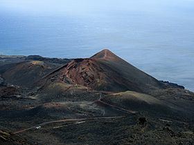
Teneguía is a monogenetic cinder cone – a vent which has been active once and is considered as being unlikely to become active in the future. It is situated on the island of La Palma, one of the Canary Islands and is located at the southern end of the sub-aerial section of the Cumbre Vieja volcano of which Teneguía is just one of several vents.
Contents
- Hotel princess tenegu a la palma dobby drone
- Map of TeneguC3ADa 38749 Santa Cruz de Tenerife Spain
- Volc n tenegu a a vista de drone
- 1971 eruption
- References
Map of Tenegu%C3%ADa, 38749, Santa Cruz de Tenerife, Spain
Volc n tenegu a a vista de drone
1971 eruption
This vent is the source of the last subaerial volcanic eruption in Spain, which occurred from October 26 to November 28, 1971. Earthquakes preceded the eruption. The eruption killed an elderly fisherman who got too close to the lava and was asphyxiated by the fumes. The eruption also caused some property damage and destroyed a beach, though a new one was later formed by natural means. Populated zones were not affected. The vent has since become an attraction for tourists and forms part of the Monumento Natural de Los Volcanes de Teneguía.