
Population 61,781 (Oct 2015) | Phone number 023-654-1111 Local time Wednesday 12:02 PM | |
 | ||
Weather 8°C, Wind W at 14 km/h, 55% Humidity Points of interest Jakushoji, Hiroshige Museum, Tendo Onsen YuPia, Tendoshi Shogi Museum, Dewazakura Museum | ||
Tendō (天童市, Tendō-shi) is a city located in Yamagata Prefecture in the Tohoku region of northern Japan.
Contents
- Map of Tendo Yamagata Prefecture Japan
- Geography
- Neighboring municipalities
- Climate
- History
- Economy
- Education
- Railway
- Highways
- Twin towns Sister cities
- Notable people
- References
Map of Tendo, Yamagata Prefecture, Japan
As of October 2015, the city had an estimated population of 61,781 and a population density of 547 persons per km2. The total area was 113.01 square kilometres (43.63 square miles).
Geography
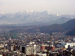
Tendō is located in the east-central portion of the Yamagata Basin, bordered by the Ōu Mountains to the east.
Neighboring municipalities
Climate
Tendō has a humid continental climate (Köppen climate classification Dfa) with very warm summers and cool winters. Precipitation is plentiful throughout the year, although the months from February to June have somewhat less rainfall.
History
During the Edo period, the area of present-day Tendō was part of Tendō Domain, a 20,000 koku feudal domain under the Tokugawa shogunate controlled by the Oda clan, who ruled from 1831-1871.
After the start of the Meiji period, the area organized as Tendō Village under Higashimurayama District, Yamagata Prefecture in 1878. It was elevated to town status on April 27, 1892 and became a city on October 1, 1958.
Economy
The economy of Tendō is based on seasonal tourism, agriculture and wood products. The city is traditionally known for its production of the wooden pieces used in Japanese chess (shogi). The city also has numerous onsen hot springs within its borders.