
Elevation 623 m Mountain range Wapack Range Parent range Wapack Range | Age of rock 400.265424 million years Easiest route Wapack Trail | |
 | ||
Location Sharon and Temple, New Hampshire Mountain type ridge; metamorphic rock Similar Pack Monadnock, North Pack Monadnock, Kidder Mountain, Mount Watatic, Barrett Mountain | ||
Temple Mountain is a 2,045-foot (623 m) ridge located in south-central New Hampshire within the Wapack Range of mountains. It lies within Sharon and Temple, New Hampshire; the 22-mile (35 km) Wapack Trail traverses the mountain, and the northern face includes the 350-acre (1.4 km2) Temple Mountain Reservation, owned by the state. The mountain is 3.5 miles (5.6 km) long and has several summits; three of them are named: Burton Peak 2,010 feet (610 m), Whitcomb Peak 1,710 feet (520 m), and Holt Peak, the high point.
Map of Temple Mountain, Temple, NH 03458, USA
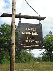
The mountain was home to the former Temple Mountain Ski Area, which is now a state-owned recreation area.
Pack Monadnock Mountain is located directly to the north along the Wapack ridgeline; Kidder Mountain to the south. Much of the north face of the mountain, formerly the Temple Mountain Ski Area, is the state-owned Temple Mountain Reservation Area. Scattered ledges along the ridgeline offer long vistas west to Mount Monadnock and south along the spine of the Wapack Range; the abandoned ski area on the north side of the mountain offers 270-degree views.
The east side of the mountain drains into the Souhegan River watershed, thence into the Merrimack River and Atlantic Ocean; the west side drains into the Contoocook River, thence into the Merrimack River.