
Population 5,177 (2011 census) | Postcode(s) 2117 State electorate(s) Parramatta Postal code 2117 | |
 | ||
Location 23 km (14 mi) north-west of Sydney CBD | ||
Telopea /təloʊpiə/ is a suburb of Sydney, in the state of New South Wales, Australia. Telopea is located 23 kilometres north-west of the Sydney central business district, in the local government area of the City of Parramatta. The suburb is bordered by Kissing Point Road to the south and Pennant Hills Road to the north.
Contents
- Map of Telopea NSW 2117 Australia
- Name
- Transport
- Commercial area
- Housing
- Parks
- Places of Worship
- Community Facilities
- Population
- References
Map of Telopea NSW 2117, Australia
Name
Telopea is named from Telopea speciosissima, the New South Wales waratah, a plant that was abundant in the area before it was colonised and which became the floral emblem of New South Wales.
Transport
Telopea railway station is on the Carlingford Line of the Sydney Trains network. The area is serviced by Sydney Buses route 545
A conversion of the Camellia to Carlingford section of the Carlingford railway line to light rail was announced in 2015 as part of the Parramatta Light Rail project.
At the 2011 census, only 18.4% of employed people travelled to work on public transport and 65.1% by car (either as driver or as passenger).
Commercial area
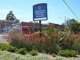
Waratah Shopping Centre, located on Benaud Place, has many retail shops including an IGA supermarket, newsagent, chemist, kebab shop, and a hair and beauty salon. A small group of shops is also located opposite the railway station on Adderton Road.
Housing
Telopea is mainly low to low-medium density housing with most of the dwellings having been built after the Second World War. The suburb is bisected by the Carlingford railway line with most of the medium-density housing lying adjacent to the train line.
Parks
Telopea contains a large tract of bushland on its western edge, backing onto the Oatlands golf course. The bushland, the Vineyard Creek Reserve as it is known contains a spring-fed creek and has several waterfalls on its course before it disappears beneath Kissing Point road to the south. The creek and the bushland are protected as environmental areas.
Places of Worship
Community Facilities
Local facilities include a primary school, an alternative educational facility, a library, community hall and a community garden.
Population
At the 2011 census, Telopea recorded a population of 5,177. Of these: