Admin. region Oberbayern Elevation 405 m (1,329 ft) Area 5.38 km² Population 1,893 (31 Dec 2008) Dialling code 08633 | Time zone CET/CEST (UTC+1/+2) Local time Tuesday 10:51 AM Postal code 84576 | |
 | ||
Weather 9°C, Wind W at 6 km/h, 57% Humidity | ||
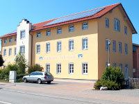
Teising is a municipality in the district of Altötting in Bavaria in Germany and belongs to the parish Burgkirchen am Wald. The village is located very centrally between the towns of Altötting and Mühldorf am Inn. Since 2008 most traffic is rerouted to the nearby freeway A94, which help the village center gain considerably in attractiveness.
Map of Teising, Germany
Teising is one of the oldest settlements in the area. Its first documented mention dates back to the year AD 710. There is evidence of Celtic settlements close by, of a main Roman road which connected Italy to the northern border of the Noricum province.
Once a dreamy village, it expanded rapidly when local farmers started selling land for new construction in the 1970s. Teising gained nationwide fame in 2000 as "debt-free" village. A recently opened business park has attracted many businesses to Teising, who value its easily accessible location, skilled workforce, and the high recreational value of Upper Bavaria.
Teising has two banks, a bakery, a butcher, two restaurants, two pubs, but no post office.
