Postcode(s) 3328 Founded 8 March 1864 Population 1,033 (2006) | Postal code 3328 Local time Tuesday 5:47 PM | |
 | ||
Location 100 km (62 mi) W of Melbourne34 km (21 mi) W of Geelong Weather 24°C, Wind W at 16 km/h, 40% Humidity | ||
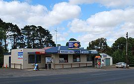
Teesdale is a rural locality in Victoria, Australia. The locality is in the Golden Plains Shire, near the regional city of Geelong and 100 kilometres (62 mi) west of the state capital, Melbourne. At the 2011 census, Teesdale had a population of 1,479.
Map of Teesdale VIC 3328, Australia
Teesdale Post Office opened on 8 March 1864.
Teesdale Pharmacy opened on 13 December 2013.
References
Teesdale, Victoria Wikipedia(Text) CC BY-SA
