
Country Philippines Congr. district 1st district Barangays Area 1,258 km² Province Palawan | Region MIMAROPA (Region IV-B) Founded 1623 Time zone PST (UTC+8) Area code 48 Dialling code 48 | |
 | ||
Neighborhoods Bantulan, Maytiguid, Calauag, Binaluan, Pancol | ||
Taytay is a first class municipality in the province of Palawan, an island of the Philippines.
Contents
- Map of Taytay Palawan Philippines
- Taytay palawan white point island 4 sale www palawanproperty com
- History
- Barangays
- References
Map of Taytay, Palawan, Philippines
According to the 2010 census, it has a population of 70,837 people.
Since 2002, its Cathedral of St. Joseph the Worker is the episcopal see of the pre-diocesan missionary Apostolic Vicariate of Taytay.
Taytay palawan white point island 4 sale www palawanproperty com
History
Before the Spanish colonization, The Kingdom of Taytay was ruled by a monarch noted as followed everywhere at any given time by ten scribes. The crew of Ferdinand Magellan held the Taytay king and queen for ransom after escaping the Battle of Mactan where Magellan was slain. They intended to secure more supplies as they plan to cross into the Moluccas where the Portuguese were so help can be sought. The native king and his subjects complied with the demands and even added more food supplies than what they asked for. This was duly recorded by Antonio Pigafetta, Magellan's chronicler, who was on board in one of the ships when these events took place.
Pigafetta also took note of one curious thing in the kingdom. He found the natives fond of cockfighting, long before this pastime was seen or even heard of in the Western Hemisphere.
During the Spanish colonization of the Philippines, Taytay was formally founded in 1623. Taytay became the capital of the province of Calamianes, the entire territory of Paragua (now Palawan), in 1818; and the province of Castilla, a land area occupying the northern part of Palawan, in 1858.
Archived baptismal records of Cuyo, Palawan show that the last monarch of the Kingdom of Taytay was converted to Christianity and christened Flores de los Santos Cabaylo meaning Cabaylo, Flower of the Saints. No other sovereign royal datu after him ruled in his kingdom. King Cabaylo's descendants include the present clans of Cabaylo-Manlavi-Gabinete-Macolor as main genealogical roots. His Royal Highness Datu Dr. Fernando Macolor Cruz who hailed from the Cabailo-Manlavi-Gabinete-Macolor line of the royal house is the present pretender and sole claimant to the most serene and ancient throne of the Kingdom of Taytay.
During the American era, Taytay ceased being Palawan's capital, and its administrative boundary was reduced by approximately 500,000 hectares upon the creation of the Municipality of El Nido in 1916.
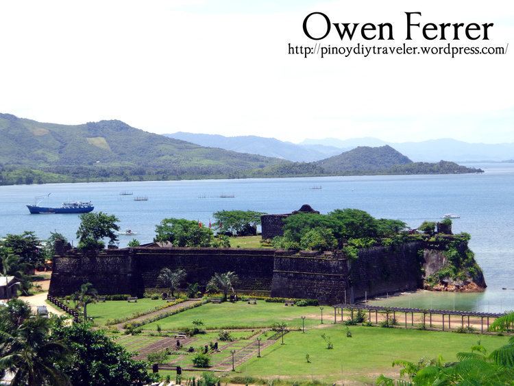
The historic Taytay Fort, the Fuerza de Santa Isabel, built in 1667 under the Augustinian Recollect Fathers and named in honor of Spain's Queen Isabela II in the 19th century, was used as a military station during that period. This famous relic was completed in 1738. It was mainly used to defend against Muslim warrior-raiders in their colorful war boats while the Spanish soldiers fire at them with their huge cannons. The fort's small chapel and cannons are still intact. The fort is now under the supervision of the National Museum. The Moro action must be understood not as an act of piracy but as a showdown of power and challenge to Spanish hugemony over the islands. It can be viewed as the Tausug's efforts to recover what was once theirs. Similar raids were also carried out against Christian converts in Spanish Cuyo, Dumaran, Linapacan and Culion.
In 1957, the Island of Dibangan was constituted into a barrio.
Barangays
Taytay is politically subdivided into 31 barangays.