
Airport type Public 5/23 5,003 Elevation 281 m | Elevation AMSL 921 ft / 281 m 5,003 1,525 Phone +1 270-789-4182 | |
 | ||
Owner Taylor County Airport Board Location Campbellsville, Kentucky Address 360 Airport Rd, Campbellsville, KY 42718, USA Similar Taylor County Middle Sc, Campbell University, Campbell High School, Family Resource & Youth S, Campbell Board of Edu | ||
Taylor County Airport (ICAO: KAAS, FAA LID: AAS) is a county-owned public-use airport located two nautical miles (4 km) northeast of the central business district of Campbellsville, a city in Taylor County, Kentucky, United States.
Although most U.S. airports use the same three-letter location identifier for the FAA and IATA, Taylor County Airport is assigned AAS by the FAA but has no designation from the IATA (which assigned AAS to Apalapsili Airport in Apalapsili, Indonesia).
Facilities and aircraft
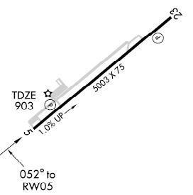
Taylor County Airport covers an area of 106 acres (43 ha) at an elevation of 921 feet (281 m) above mean sea level. It has one asphalt paved runway designated 5/23 which measures 5,003 x 75 feet (1,525 x 23 m). For the 12-month period ending May 19, 2006, the airport had 10,200 aircraft operations, an average of 27 per day: 75% general aviation, 16% air taxi and 9% military.