
Grid position 198/297 PAL Governorate Nabatieh Governorate Elevation 660 m (2,170 ft) Area code +961 | Country Lebanon District Marjeyoun District Time zone EET (UTC+2) | |
 | ||
Archaeologists Louis Dubertret, Jacques Cauvin | ||
Tayibe, Et Tayibe or Et Taibeh is a village in the Marjeyoun District in south Lebanon.
Contents
Map of Taybeh, Lebanon
Name
According to E. H. Palmer, the name Tayibe means "The good, sweet, or wholesome" (about water).
Archaeological site
By the village is a Heavy Neolithic archaeological site of the Qaraoun culture.
The site was discovered by Louis Dubertret and materials studied by Jacques Cauvin. Heavy Neolithic materials recovered resembled those from Qaraoun.
History
In 1875, Victor Guérin found here a village with 800 Metualis. He further noted: "Its principal mosque, now in ruins, is built of superb blocks, apparently ancient. It contains in the interior several monolithic columns."
In 1881, the Palestine Exploration Fund's Survey of Western Palestine (SWP) noted here: "There are several sarcophagi and cisterns in the village ; some caves near." They further described it as: "A large well-built village, built of stone, containing about 600 Metawileh and 400 Moslems. The Caimacam has a good house here. There are some figs and olives round the village and arable land; water is supplied from a spring and two birkets."
Modern era
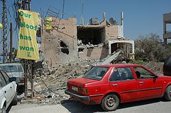
On August 5, during the 2006 Lebanon War, Israeli war-planes killed 3 civilians, aged 2 to 48 years of age. The IDF offered no explanations to the strike.