Population 32,595 (1 Oct 2007) | Local time Monday 10:46 PM | |
 | ||
Time zone Japan Standard Time (UTC+9) City hall address 890-1 Tawarmoto-chō, Nara-ken636-0392 Weather 3°C, Wind W at 14 km/h, 82% Humidity Points of interest Karako‑Kagi Archaeological Museum, Jinraku‑ji, Tsushima Shrine | ||
Tawaramoto (田原本町, Tawaramoto-chō) is a town located in Shiki District, Nara Prefecture, Japan.
Contents
- Map of Tawaramoto Shiki District Nara Prefecture Japan
- Geography
- Surrounding municipalities
- Education
- References
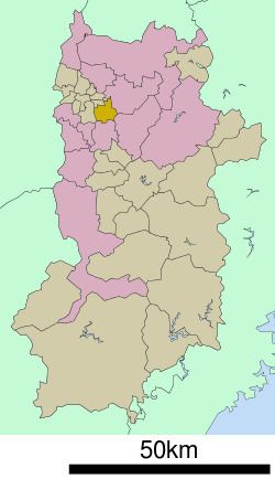
Map of Tawaramoto, Shiki District, Nara Prefecture, Japan
As of October 1, 2007, the town has an estimated population of 32,595. The total area is 21.10 km². It has many temples and shrines including Jinrakuji.
Geography
Located in the center of the Nara Basin, the majority of the land is flat. The Yamato River flows through the eastern portion of the town.
Surrounding municipalities
Education
References
Tawaramoto, Nara Wikipedia(Text) CC BY-SA
