
 | ||
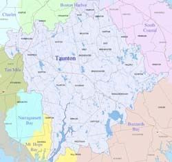
The Taunton River watershed or Taunton River basin is made up of 562 square miles (1,500 km2) of rivers, lakes, ponds, streams, and wetlands in southeastern Massachusetts, USA. It is the second largest watershed in the state. Also, it is a significant part of a much larger multi-state watershed, the Narragansett Bay watershed.
The Taunton River watershed is mostly situated in Bristol County and western Plymouth County, while some portions of it extends into parts of southern Norfolk County.
The Taunton River watershed includes:
Environmental advocacyEdit
This is an incomplete list of environmental groups and organizations that advocate protecting, by legislation and grants, the Taunton River Watershed:
References
Taunton River Watershed Wikipedia(Text) CC BY-SA