
- right O'Donnel River | Basin area 1,900 km² | |
 | ||
- location Bayambang, Pangasinan, Ilocos Region | ||
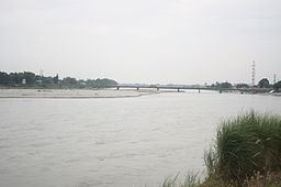
Tarlac River is a river in Central Luzon, Philippines, covering a drainage area of 1,900 square kilometers traversing the provinces of Tarlac and Pangasinan. The river originates around the vicinity of Mount Pinatubo and empties itself into the Agno River at Poponto Swamp located between the boundaries of Tarlac and Pangasinan. It was formerly the site of traditional balsa or bamboo raft riding, until the river was heavily silted by sticky lahar or mud flow brought by the eruption of Mount Pinatubo on June 15, 1991, filling the river with over 10 feet of lahar. Its main tributary is the O'Donnel River in Sta. Lucia Capas, Tarlac.
Map of Tarlac River, Philippines
Tarlac river is dammed at Barangay Tibag in Tarlac city where its water is used for irrigation and distributed to the northern and central regions of Tarlac, the rest of the river is now a bed of sand. The river was once a good source of fish and water used for irrigation, the irrigation system now takes just about "all" of the remaining water and distributes it to barangays in Tarlac City such as Matatalaib and Maliwalo. The river bed is also being used as a source of sand and stones that can be used as construction materials.