
Population 855 (2011 census) Postal code 4421 | Postcode(s) 4421 Tara Goranba Local time Monday 7:42 AM | |
 | ||
Weather 22°C, Wind E at 13 km/h, 84% Humidity | ||
Tara is a town and locality in the Western Downs Region, Queensland, Australia. At the 2011 census, Tara had a population of 855.
Contents
Map of Tara QLD 4421, Australia
Geography
Tara is on the Darling Downs. Immediately surrounding the urban area of Tara, there are a number of rural subdivisions of 'lifestyle blocks'. The blocks are usually between 13 and 40 ha in area. The population of the 2000 Rural Subdivision blocks exceeds that of the town itself.
Economy
Important industries in the area around Tara include wheat, beef, wool and gas.
On 14 March 2011 a blockade against coal seam gas development began at a property called Kenya near Tara. The following day a woman was arrested after she stopped the movement of a bulldozer working for Queensland Gas Company. The next month Bob Irwin was arrested and fined for participating in a rally at the same location. He was protesting against plans to build a coal seam gas pipeline.
Attractions
Attractions near Tara include Southwood National Park, a remnant area of the southern brigalow belt.
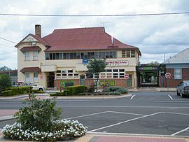
The Commercial Hotel has two murals painted by artist Hugh Sawrey, from nearby Kogan. Painted in 1960, they are You’ll come a waltzing Matilda with me and Clancy’s gone to Queensland droving.