
 | ||
Tao-Klarjeti (Georgian: ტაო-კლარჯეთი) is a part of Georgian historical region of Upper Kartli and the term is based on the names of two most important provinces of the region — Tao and Klarjeti.
Contents
Geography
Tao-Klarjeti completely covers the basin of river Chorokhi and the toponym doesn't extend beyond its boundaries. Therefore in Tao is meant that territory of the basin of riv. Chorokhi which starts in the confluence of rivers Imerkhevi and Chorokhi and continues towards Bayburt, while the part of the basin of riv. Chorokhi which starts in Imerkhevi and continues before the shores of Black Sea is Klarjeti. Tao itself is divided into the territories of Speri and Taoni and Klarjeti consists territories of the basin of riv. Imerkhevi such as Shavsheti and Imerkhevi. Part of Klarjeti which is located from Imerkhevi-Chrokhi confluence before Black sea has been divided into the valleys of Nigali, Ajara and Machakhela. Lots of Georgian important cultural monuments from the middle ages are located on the territory of Tao-Klarjeti and many of them are preserved as ruins.
Georgian states also included the historical province of Basiani. Other provinces from South-Western Georgia, such as Kola, Artaani and Erusheti are also part of upper kartli historical region.
History
The region of Tao-Klarjeti has been under the influence of many states and empires during its long history. In the ancient past the Kingdom of Diaokhi arose in the center of it. Tao-Klarjeti has become the cultural and political center of Georgian statehood in early and high medieval period when the Principality of Iberia got renovated by Ashot I the Great. In 888 Adarnase IV of Iberia crowned himself as a king. On that day the Kingdom of the Kartvels (Georgians) originated which existed before the unification of it with the Kingdom of the Abkhazes, establishing united Georgian state in 1008.
The area continued to remain a Georgian territory and was administered by the princes of Samtskhe-Saatabago until conquered by the Ottomans in 1551. During their rule, a policy of Islamization was implemented and many of the Christian churches were converted into mosques. Following the Russian-Turkish war of 1877-1878, most of the former Tao-Klarjetian territory was ceded to the Russian Empire, but it was taken back by the Turks in the Brest-Litovsk Treaty with the Russian SFSR in 1918. The Ottoman defeat in World War I allowed the newly created Democratic Republic of Georgia to regain control of the region. Olti district, which was heavily contested between Georgians and Armenians had stayed under Turkish control. However, the nation’s independence soon collapsed under the Soviet Red Army attack in February 1921 and simultaneously the area was reoccupied by Turkey, a fact that was acknowledged by the Treaty of Moscow signed between the Turkish and Soviet governments on 16 March 1921.
Architecture
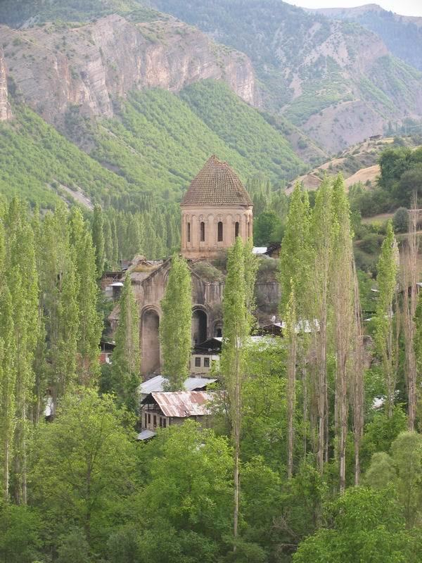
Several monuments of medieval Georgian architecture – abandoned or converted churches, monasteries, bridges and castles – are scattered across the area. Best known are the monasteries of Khandzta, Khakhuli, Ancha, (Turk. Haho/Bağbaşi), the churches of Oshki (Turk. Öşk Vank/Çamlıyamaç), Ishkhani (Turk. Işhan), Bana (Turk. Penek), Parkhali (Turk. Barhal/Altıparmak), Doliskana (Turk. Dolişhane/ Hamamlıköy), Otkhta Eklesia (Turk. Dörtkilise), Opiza (Turk. Bağcılar), Parekhi and Tbeti (Turk. Cevizli).