
Country Philippines Barangays ZIP code 5612 Province Aklan | District Lone district Time zone PST (UTC+8) Area 74.59 km² | |
 | ||
Region Western Visayas (Region VI) | ||
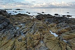
Skim spot spotted jawili beach tangalan aklan
Tangalan, officially the Municipality of Tangalan (Aklanon: Banwa it Tangalan; Hiligaynon: Banwa sang Tangalan; Filipino: Bayan ng Tangalan), is a municipality in the province of Aklan in the Western Visayas (Region VI) of the Philippines. The population was 21,916 at the 2015 census. In the 2016 electoral roll, it had 12,736 registered voters.
Contents
- Skim spot spotted jawili beach tangalan aklan
- Map of Tangalan Aklan Philippines
- Dancing kid of tamalagon tangalan aklan
- Geography
- Barangays
- Demographics
- Attractions
- References
Map of Tangalan, Aklan, Philippines
Tangalan was formerly an arrabal of Makato. At the time of its creation, it included the following barrios: Tondog, Jawili, Dumatad, Afga, Baybay, Dapdap, Pudyot, Tagas, Tamalagon, Panayakan, Vivo, Lanipga, Napatag and Tamokoe.
Dancing kid of tamalagon tangalan aklan
Geography
Tangalan is located at 11°46′N 122°15′E.
According to the Philippine Statistics Authority, the municipality has a land area of 74.59 square kilometres (28.80 sq mi) constituting 7000410009999999999♠4.10% of the 1,821.42-square-kilometre- (703.25 sq mi) total area of Aklan.
Barangays
Tangalan is politically subdivided into 15 barangays.
Demographics
In the 2015 census, Tangalan had a population of 21,916. The population density was 290 inhabitants per square kilometre (750/sq mi).
In the 2016 electoral roll, it had 12,736 registered voters.
Attractions
Tourist spots with government support under "Project Bugna" include Jawili Falls, Jawili Beach Resorts, Dumatad Souvenir Shop, and Bughawi Reforestation Project.
The Tangalan Marine Sanctuary covers 375 hectares (930 acres) of marine ecosystem and a 10 hectares (25 acres) coral garden.