
Length 361 km | Mouth Tanafjord Mouth elevation 0 | |
 | ||
- average 197 m/s (6,957 cu ft/s) | ||
The Tana (Finnish: Teno or Tenojoki; Northern Sami: Deatnu; Norwegian: Tanaelva; Swedish: Tana älv), is a 361-kilometre (224 mi) long river in the Sápmi area of northern Scandinavia. The river flows through Finnmark county, Norway and the Lapland region of Finland. The Sámi name means "Great River". The main tributaries of Tana are Anarjohka and Karasjohka.
Contents
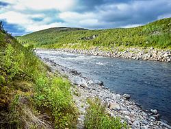
Map of Tana, Tana Municipality, Norway
Geography
In its upper course it runs for 256 km (159 mi) along the Finnish–Norwegian border, between the municipalities of Utsjoki, Finland and Karasjok and Tana, Norway. The river is the fifth longest in Norway. The last 105 kilometres (65 mi) of the river run through the municipality of Tana in Norway. The river discharges into the Tanafjorden, one of the largest and most unspoiled river deltas in Europe. The delta is protected and is an important home to wetland birds. There are large deposits of sand in the delta that are exposed sandbars at low tide.
Fishing
The Tana is well known for its excellent salmon fishery and is the most productive salmon river in Finland and Norway. The world's record for Atlantic salmon is held by a salmon caught on the Tana; it was 36 kilograms (79 lb) and was taken in 1929 by the late Nils Mathis Walle.
In 2002, fishermen on the river captured an annual total of 99,546 kilograms (219,461 lb) salmon with an average size of 4.5 kilograms (9.9 lb) in the river. The annual sea trout catch for that year on the river was 4,426 kilograms (9,758 lb). Both Finland and Norway regulate the fishing on the river and drift net fishing is allowed on the river.
Transportation
The Tana Bridge was constructed in 1948; its main span is 195 metres (640 ft). The Sami Bridge at Utsjoki was constructed in 1993. The European route E06 highway follows the western shoreline of the river for most of the length of the river.
In winter, there are usually two ice roads that are in use from December to April. These roads have a weight limit of 2 tonnes (2.0 long tons; 2.2 short tons), but few other limitations.