
Country Norway District Øst-Finnmark Area rank 5 in Norway Area 4,050 km² | County Finnmark Administrative centre Tana Bru Demonym(s) Tanaværing Local time Sunday 11:28 AM | |
 | ||
Weather 3°C, Wind W at 35 km/h, 70% Humidity Points of interest Sieiddájohgárggu, Gietteriddu, Áđgagáddi | ||
Deatnu (Northern Sami) or Tana (Norwegian) is a municipality in Finnmark county, Norway. The administrative centre of the municipality is the village of Tana Bru. Other villages in the municipality include Austertana, Bonakas, Polmak, Rustefjelbma, and Skiippagurra.
Contents
- Map of Tana Municipality Norway
- General information
- Name
- Coat of arms
- Churches
- Geography
- Birdlife
- References
Map of Tana Municipality, Norway
General information
The municipality of Tana was established on 1 January 1864 when the eastern part of the large municipality of Lebesby was separated to become a new municipality with a population of 1,388. The original municipality included all the land on both sides surrounding the Tanafjorden and the Tana River.
On 1 January 1914, the municipality of Tana was divided into three parts. The southern part (population: 1,426) remained as (a smaller) Tana Municipality. The northern part of the municipality was divided by the Tanafjorden with the western side becoming Gamvik Municipality (population: 1,374) and the eastern side becoming Berlevåg Municipality (population: 784). On 1 January 1964, the neighboring municipality of Polmak (population: 1,072), which had separated from Nesseby Municipality on 1 January 1903, was merged into Tana.
Name
Tana is a Norwegianized form of the Sami name Deatnu. The Sami name is identical with the Sami word deatnu which means "great river" or "main river", referring to the main river (Tana River) which runs through the municipality.
Prior to 1918, the name was written "Tanen". On 1 September 1992, the name was changed to "Deatnu-Tana" to symbolize the two official languages in the municipality. Then in 2005, the name was again changed such that either Deatnu or Tana can be used.
Coat-of-arms
The coat-of-arms is from modern times. They were granted on 11 May 1984. The arms show three typical low riverboats used for centuries in the area. The three boats symbolise the Sami, Finns, and Norwegians that live in this border municipality. The colours are the Norwegian colours.
Churches
The Church of Norway has two parishes (sokn) within the municipality of Tana. It is part of the Indre Finnmark deanery in the Diocese of Nord-Hålogaland.
Geography
Deatnu-Tana is situated along the lower river basin of the Tana River, which borders Finland along most of its course. People live in small settlements along the river, notably Sirma, Polmak, Rustefjelbma, Seida, Skiippagurra, Austertana, and Tana Bru. Most inhabitants of Tana are Sami people, and the Sami language and culture are today promoted by the municipality and the schools.
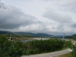
The river Tana has represented a mainstay in the economy, as it is one of Europe's main salmon rivers, and it empties into the Tanafjorden. River transportation is traditionally done by long, narrow river boats, that are still in use, albeit motorized. Lakes in this area include Geassájávri, Nissojávri, and Sundvatnet. At Tana Bru, the Tana Bridge (part of European route E6 and European route E75) crosses over the Tana River. The nearest airports are Vadsø Airport (about 70 kilometres or 43 miles away) and Kirkenes Airport (about 130 kilometres or 81 miles away). Kirkenes Airport (but not Vadsø) has direct flights to Oslo.
Birdlife
With the Tana River flowing through wild and spectacular habitat, the municipality of Tana has one of the most spectacular gatherings in Norway. As many as 25,000 goosanders can accumulate along the Tana waterway system. Add to this, thousands of common eider and long-tailed duck, then you have one of the largest concentrations of wildfowl in Norway.