
Local time Sunday 5:27 PM | Population 37,741 (Dec 2014) | |
 | ||
Weather 2°C, Wind SE at 14 km/h, 93% Humidity Points of interest Abukuma‑do, Hoshinomura Observatory, Okaburaya Shrine, Katasoneyama, Takashibayama | ||
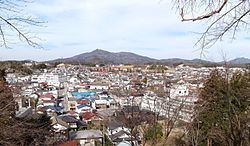
Tamura (田村市, Tamura-shi) is a city located in Fukushima Prefecture, in northern Honshū, Japan. As of December 2014, the city had an estimated population of 37,741 and a population density of 82.3 persons per km². The total area was 458.30 km².
Contents
- Map of Tamura Fukushima Prefecture Japan
- Geography
- Neighboring municipalities
- History
- Evacuation after the Fukushima Daiichi Nuclear Disaster
- Education
- Railway
- Highway
- International relations
- Local attractions
- Noted people from Tamura
- References
Map of Tamura, Fukushima Prefecture, Japan
Geography
Tamura is located in east-central Fukushima Prefecture.
Neighboring municipalities
History
The area of present-day Tamura was part of ancient Mutsu Province. After the Meiji Restoration, it was organized as part of Tamura District in the Nakadōri region of Iwaki Province. . The villages of Miyakoji, Tokiwa, Katasone, Takine, and Ōgoe were established with the creation of the municipalities system on April 1, 1889. Tokiwa was elevated to town status on July 1, 1898, and the village of Katasone became the town of Funehiki on April 1, 1934. Takine was elevated to town status of April 1, 1940 followed by Ōgoe on February 8, 1942/
The modern city of Tamura was established on March 1, 2005, from the merger of these four towns and one village.
Evacuation after the Fukushima Daiichi Nuclear Disaster
After the Fukushima Daiichi Nuclear Disaster on 11 March 2011, the area containing the former village of Miyakoji was evacuated. On 1 April 2012 residents were allowed to return during daytime hours as decontamination work progressed. The evacuation order was lifted on 1 April 2014. However, doubts remain as to the effectiveness of the radiation decontamination efforts.