
Area code(s) 641 Elevation 256 m Population 2,842 (2013) | Time zone Central (CST) (UTC-6) FIPS code 19-77115 Zip code 52339 Local time Saturday 9:56 PM | |
 | ||
Weather 5°C, Wind NE at 18 km/h, 100% Humidity | ||
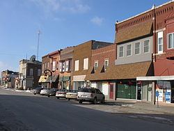
Tama iowa on us highway 30 west
Tama is a city in Tama County, Iowa, United States. The population was 2,877 at the 2010 census.
Contents
- Tama iowa on us highway 30 west
- Map of Tama IA USA
- History
- Geography
- 2010 census
- 2000 census
- Healthcare
- Politics
- References
Map of Tama, IA, USA
Tama is situated two miles south of Toledo, the county seat. The two towns are close enough to have nearly grown together over the years.
History
Tama had its start in the year 1862 by the building of the Cedar Rapids and Missouri River Railroad through that territory.
Tama is located a few miles from the Meskwaki Settlement, Iowa's only significant Native American community. Tama was located on the historic Lincoln Highway and is home to an original Lincoln Highway bridge, listed on the National Register of Historic Places. Tama is named for Taimah, the 19th century Meskwaki leader.
Geography
According to the United States Census Bureau, the city has a total area of 3.41 square miles (8.8 km2), of which, 3.26 square miles (8.4 km2) is land and 0.15 square miles (0.39 km2) is water.
2010 census
As of the census of 2010, there were 2,877 people, 1,092 households, and 708 families residing in the city. The population density was 882.5 inhabitants per square mile (340.7/km2). There were 1,234 housing units at an average density of 378.5 per square mile (146.1/km2). The racial makeup of the city was 78.4% White, 0.5% African American, 5.8% Native American, 0.3% Asian, 9.7% from other races, and 5.2% from two or more races. Hispanic or Latino of any race were 23.6% of the population.
There were 1,092 households of which 36.5% had children under the age of 18 living with them, 47.9% were married couples living together, 11.6% had a female householder with no husband present, 5.3% had a male householder with no wife present, and 35.2% were non-families. 29.0% of all households were made up of individuals and 15.2% had someone living alone who was 65 years of age or older. The average household size was 2.58 and the average family size was 3.21.
The median age in the city was 35.6 years. 28.7% of residents were under the age of 18; 8.6% were between the ages of 18 and 24; 24.5% were from 25 to 44; 22.3% were from 45 to 64; and 16.1% were 65 years of age or older. The gender makeup of the city was 48.7% male and 51.3% female.
2000 census
As of the census of 2000, there were 2,731 people, 1,065 households, and 723 families residing in the city. The population density was 905.1 people per square mile (349.2/km²). There were 1,173 housing units at an average density of 388.7 per square mile (150.0/km²). The racial makeup of the city was 87.04% White, 0.40% African American, 4.80% Native American, 0.40% Asian, 5.24% from other races, and 2.12% from two or more races. Hispanic or Latino of any race were 9.63% of the population.
There were 1,065 households out of which 33.2% had children under the age of 18 living with them, 51.6% were married couples living together, 12.5% had a female householder with no husband present, and 32.1% were non-families. 28.1% of all households were made up of individuals and 16.5% had someone living alone who was 65 years of age or older. The average household size was 2.51 and the average family size was 3.08.
Age spread: 27.4% under the age of 18, 8.1% from 18 to 24, 25.0% from 25 to 44, 20.7% from 45 to 64, and 18.8% who were 65 years of age or older. The median age was 37 years. For every 100 females there were 91.2 males. For every 100 females age 18 and over, there were 82.4 males.
The median income for a household in the city was $35,531, and the median income for a family was $43,750. Males had a median income of $33,672 versus $22,237 for females. The per capita income for the city was $16,676. About 8.8% of families and 12.3% of the population were below the poverty line, including 17.3% of those under age 18 and 16.9% of those age 65 or over.
Healthcare
Toledo area residents have access to healthcare services at the Deer Creek Health Center or the Tama Medical Center (now a branch of MMSC). When hospitalization is required the closest and most convenient hospital for residents is Grinnell Regional Medical Center or Marshalltown Medical and Surgical Center.
Politics
Tama is the headquarters of the Sac and Fox Tribe of the Mississippi in Iowa.