
 | ||
Tallassee (also "Talassee," "Talisi," "Tellassee," and various similar spellings) is a prehistoric and historic Native American site in Blount County and Monroe County, Tennessee, in the southeastern United States. Tallassee was the southernmost of a string of Overhill Cherokee villages that spanned the lower Little Tennessee River in the 18th century. Although it receives scant attention in primary historical accounts, Tallassee is one of the few Overhill towns to appear on every major 18th-century map of the Little Tennessee Valley.
Contents
The Tallassee site is now submerged by Chilhowee Lake, an impoundment of the Little Tennessee River created by the completion of Chilhowee Dam in 1957. The shoreline above the site is now home to the Calderwood Hydroelectric Development Area, which was established by the Aluminum Company of America in the 1920s as a base for the construction of Cheoah, Santeetlah, and Calderwood dams further up the river. The modern hamlet of Tallassee—established in the early 20th century—is located 7 miles (11 km) downstream, near Chilhowee Dam.
Geographical setting
After winding its way through the mountains of Georgia and North Carolina, the Little Tennessee River crosses into Tennessee, where it flows for another 54 miles (87 km) before emptying into the Tennessee River near Lenoir City. Chilhowee Dam, situated approximately 34 miles (55 km) above the mouth of the river, retains a reservoir that spans the river for 10 miles (16 km), all the way to the base of Calderwood Dam. The Tallassee site was located 41.5 miles (66.8 km) above the river's mouth, at the river's confluence with Tallassee Creek. According to 18th-century records, the village was situated on both banks of the river. Calderwood Dam is located just 2 miles (3.2 km) above the Tallassee site, opposite a U-shaped bend in the river.
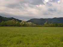
The Tallassee site is surrounded by high mountains on all sides. The Great Smoky Mountains rise to the north and east and the Unicoi Mountains rise to the south and west. The Little Tennessee provides the immediate boundary between the Great Smoky Mountains National Park and the Cherokee National Forest.
The Calderwood Hydroelectric Development Area— located on the shores above the ancient Tallassee site— is accessible just off U.S. Route 129 approximately 6 miles (9.7 km) south of the road's Foothills Parkway junction. The area is open to the public daily from 8 A.M to 3 P.M. Just beyond Calderwood, US-129 enters a dangerous switchback-laden stretch of road known as "The Dragon."
History
Perhaps due to its remote location amidst high mountains, Tallassee received little attention from explorers, traders, and diplomats throughout the 18th century. The village appears on George Hunter's map of the Cherokee country in 1730 along with Citico and Tanasi. The "head man" of Tallassee was one of several Overhill and Middle town chiefs that met with Colonel George Chicken at the Tanasi townhouse in 1725 to forge an alliance against the Creeks. Tallassee again appears on Henry Popple's 1733 "Map of the British Empire in North America" along with Citico and Tanasi. In 1751, South Carolina records list Tallassee as one of seven Overhill towns. The same seven are shown on John Mitchell's 1755 map of North America.
In 1761-1762, Henry Timberlake visited the Overhill towns as an envoy during a peace tour following the Anglo-Cherokee War. Timberlake's map shows a townhouse and 22 dwellings (15 on the east bank and 7 on the west bank) at Tallassee. The map also reports 47 warriors residing at Tallassee— the third smallest contingent in the valley (only Mialoquo and Tanasi had fewer warriors)— and states that Tallassee's "governor" had recently died and had yet to be replaced.
The Cherokee–American wars, which raged in the late 1770s, 1780s, and early 1790s, saw the destruction of most of the Overhill towns and the valley's subsequent decline. In 1776, Colonel William Christian invaded the Overhill country and destroyed a number of villages, but spared Tallassee. A militia detachment under Major Jonathan Tipton attempted to burn Tallassee in 1780, but abandoned his assault when the river proved impassable. Tallassee was finally burned by John Sevier in 1788, largely in retaliation for the Nine Mile Creek massacre. The village was attacked again in 1795 by Colonel Alexander Kelley, killing 8 villagers. Tallassee was abandoned in 1819 after the Cherokee signed the Treaty of Calhoun, ceding the Little Tennessee Valley to the United States. For most of the 19th and early 20th centuries, Tallassee was the site of a river ford connecting the Calloway Turnpike and the Parson's Turnpike.
The modern hamlet of Tallassee
In the early 20th century, a railroad station named Tallassee was established approximately 7 miles (11 km) downstream from the ancient village, near the modern Chilhowee Dam. Around 1928, several investors attempted to establish a mountain resort at this station. Cabins were built and sold, but the project ultimately failed. A small community remains at the new Tallassee, however, and the Tellico Reservoir Development Agency has established a boat ramp across the street from the old general store.
Archaeological findings
When ALCOA announced plans to build Chilhowee Dam in 1955, the Knoxville Chapter of the Tennessee Archaeological Society (under the guidance of Thomas Lewis and Madeline Kneburg of the University of Tennessee) began conducting salvage excavations at the Chilhowee and Tallassee sites, both of which would be flooded by the reservoir. As surface investigations recovered few artifacts at Chilhowee, however, the focus was shifted to Tallassee.
Materials gathered from the Tallassee excavations revealed sporadic habitation dating to as early as the Woodland period (1000 B.C.–1000 A.D.) and occurring throughout the Mississippian period (900–1600 A.D.). A prehistoric substructure mound was also located at the site, on the east bank of the river. Excavators uncovered 145 burials at Tallassee—27 of which were classified as Cherokee—and 18 refuse pits. Grave goods accompanying the Cherokee burials included glass beads, iron tools, brass implements, copper arrowheads, and a jaw harp. Excavators also uncovered remnants of a house that had been burned and the foundations of an early 19th-century cabin.